Tournon-sur-Rhône | |
|---|---|
Subprefecture and commune | |
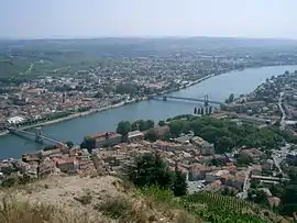
 A view across the river in Tournon-sur-Rhône | |
 Coat of arms | |
Location of Tournon-sur-Rhône | |
 Tournon-sur-Rhône  Tournon-sur-Rhône | |
| Coordinates: 45°04′05″N 4°50′00″E / 45.0681°N 4.8333°E | |
| Country | France |
| Region | Auvergne-Rhône-Alpes |
| Department | Ardèche |
| Arrondissement | Tournon-sur-Rhône |
| Canton | Tournon-sur-Rhône |
| Intercommunality | CA Arche Agglo |
| Government | |
| • Mayor (2020–2026) | Frédéric Sausset[1] |
| Area 1 | 21.01 km2 (8.11 sq mi) |
| Population | 11,191 |
| • Density | 530/km2 (1,400/sq mi) |
| Time zone | UTC+01:00 (CET) |
| • Summer (DST) | UTC+02:00 (CEST) |
| INSEE/Postal code | 07324 /07300 |
| Elevation | 115–508 m (377–1,667 ft) (avg. 123 m or 404 ft) |
| 1 French Land Register data, which excludes lakes, ponds, glaciers > 1 km2 (0.386 sq mi or 247 acres) and river estuaries. | |
Tournon-sur-Rhône (French: [tuʁnɔ̃ syʁ ʁon]; Occitan: Tornon) is a commune in the Ardèche department of southern France. It is one of the most populous communes in the Ardèche department, after Annonay, Aubenas, and Guilherand-Granges.
Geography
It is located on the right bank of the river Rhône, in the Ardèche departement,[3] opposite Tain-l'Hermitage, (which is located in the Drôme département).
History
Tournon had its own counts as early as the 9th century reign of Louis I. In the middle of the 17th century the title passed from them to the dukes of Ventadour.[3]
Population
|
| |||||||||||||||||||||||||||||||||||||||||||||||||||||||||||||||||||||||||||||||||||||||||||||||||||||||||||||||||||||
| Source: EHESS,[4] INSEE (1968-2017),[5] INSEE (1968-2020)[6] | ||||||||||||||||||||||||||||||||||||||||||||||||||||||||||||||||||||||||||||||||||||||||||||||||||||||||||||||||||||||
Notable sights
- The church of St Julian dates chiefly from the 14th century.
- The lycée occupies an old college founded in the 16th century by Cardinal François de Tournon, and is today still a functioning high school Lycée Gabriel-Faure but is occasionally open for tours.[7]
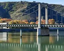
- One of the two suspension bridges which unite the town with Tain-l'Hermitage on the left bank of the river is the Passerelle Marc-Seguin. It was built in 1825 and is the oldest suspension bridge in France, today carrying only pedestrians.
- The Château de Tournon has a museum and commanding views over the Rhône.
Notable people
- François de Tournon (1489-1562), cardinal, Archbishop of Aude, then of Lyon, advisor to King Francis I
- Jean-Antoine Courbis (1752–1795), lawyer and revolutionary
- Sébastien Joly (born 1979), racing cyclist, coach and sports director
- Greta Richioud (born 1996), racing cyclist
See also

Gustave-Toursier bridge with the Tour de la Vierge in the background
References
- ↑ "Répertoire national des élus: les maires". data.gouv.fr, Plateforme ouverte des données publiques françaises (in French). 2 December 2020.
- ↑ "Populations légales 2021". The National Institute of Statistics and Economic Studies. 28 December 2023.
- 1 2 One or more of the preceding sentences incorporates text from a publication now in the public domain: Chisholm, Hugh, ed. (1911). "Tournon". Encyclopædia Britannica. Vol. 27 (11th ed.). Cambridge University Press. p. 107.
- ↑ Des villages de Cassini aux communes d'aujourd'hui: Commune data sheet Tournon-sur-Rhône, EHESS (in French).
- ↑ Population en historique depuis 1968, INSEE
- ↑ Dossier complet Commune de Tournon-sur-Rhône (07324), INSEE
- ↑ "Visites guidées". L’Association Sauvegarde du Patrimoine du lycée Gabriel Faure. Retrieved 12 March 2023.
Further reading
Wikimedia Commons has media related to Tournon-sur-Rhône.
This article is issued from Wikipedia. The text is licensed under Creative Commons - Attribution - Sharealike. Additional terms may apply for the media files.