Vallon-Pont-d'Arc | |
|---|---|
 | |
.svg.png.webp) Coat of arms | |
Location of Vallon-Pont-d'Arc | |
 Vallon-Pont-d'Arc  Vallon-Pont-d'Arc | |
| Coordinates: 44°24′28″N 4°23′40″E / 44.4078°N 4.3944°E | |
| Country | France |
| Region | Auvergne-Rhône-Alpes |
| Department | Ardèche |
| Arrondissement | Largentière |
| Canton | Vallon-Pont-d'Arc |
| Government | |
| • Mayor (2020–2026) | Guy Massot[1] |
| Area 1 | 28.62 km2 (11.05 sq mi) |
| Population | 2,443 |
| • Density | 85/km2 (220/sq mi) |
| Time zone | UTC+01:00 (CET) |
| • Summer (DST) | UTC+02:00 (CEST) |
| INSEE/Postal code | 07330 /07150 |
| Elevation | 60–434 m (197–1,424 ft) (avg. 118 m or 387 ft) |
| 1 French Land Register data, which excludes lakes, ponds, glaciers > 1 km2 (0.386 sq mi or 247 acres) and river estuaries. | |
Vallon-Pont-d'Arc (French pronunciation: [valɔ̃ pɔ̃ daʁk]; Occitan: Valon) is a commune in the Ardèche department, Auvergne-Rhône-Alpes region, Southern France.
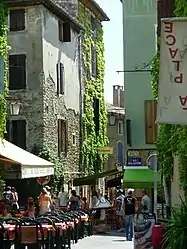
Vallon-Pont-d'Arc is a capital of prehistoric and cultural tourism. This small village, peaceful in wintertime, sees its population expand ten-fold in summer. Its tourist importance largely comes from the fact that it is the departure point for the river descent of the Gorges de l'Ardèche (from Pont d'Arc to Saint-Martin-d'Ardeche).
Geography
Vallon-Pont-d'Arc is situated at the threshold of one of the most beautiful tourist sites of France: "les gorges de l'Ardèche" (the Ardèche gorge). The famous Pont d'Arc, a natural arch more than 30 metres high, carved out by the Ardèche and classified as a Great Site of France, gave it its name.
1.8 km (1.1 mi) southeast of the village, the River Ibie flows into the Ardèche, which forms all of the commune's southwestern border.
Climate
Vallon-Pont-d'Arc has a humid subtropical climate (Cfa) according to the Köppen climate classification.
| Climate data for Vallon-Pont-d'Arc (120m, 1991–2010 averages, extremes 1991-2020) | |||||||||||||
|---|---|---|---|---|---|---|---|---|---|---|---|---|---|
| Month | Jan | Feb | Mar | Apr | May | Jun | Jul | Aug | Sep | Oct | Nov | Dec | Year |
| Record high °C (°F) | 19.7 (67.5) |
22.2 (72.0) |
29.1 (84.4) |
31.2 (88.2) |
35 (95) |
40.8 (105.4) |
40.5 (104.9) |
42.1 (107.8) |
36.6 (97.9) |
30 (86) |
21.9 (71.4) |
17.7 (63.9) |
42.1 (107.8) |
| Mean daily maximum °C (°F) | 8.5 (47.3) |
11.3 (52.3) |
16.2 (61.2) |
19.2 (66.6) |
23.8 (74.8) |
28 (82) |
31.2 (88.2) |
30.8 (87.4) |
24.7 (76.5) |
18.6 (65.5) |
12.5 (54.5) |
8.8 (47.8) |
19.5 (67.1) |
| Daily mean °C (°F) | 4.6 (40.3) |
6.1 (43.0) |
9.9 (49.8) |
12.7 (54.9) |
16.9 (62.4) |
20.7 (69.3) |
23.3 (73.9) |
23.1 (73.6) |
18.3 (64.9) |
13.9 (57.0) |
8.6 (47.5) |
5.1 (41.2) |
13.6 (56.5) |
| Mean daily minimum °C (°F) | 0.6 (33.1) |
0.9 (33.6) |
3.6 (38.5) |
6.1 (43.0) |
10 (50) |
13.4 (56.1) |
15.5 (59.9) |
15.4 (59.7) |
11.9 (53.4) |
9.2 (48.6) |
4.6 (40.3) |
1.5 (34.7) |
7.8 (46.0) |
| Record low °C (°F) | −10.5 (13.1) |
−10.2 (13.6) |
−12.5 (9.5) |
−3.5 (25.7) |
−0.8 (30.6) |
5.9 (42.6) |
7.1 (44.8) |
7.6 (45.7) |
2.1 (35.8) |
−2.9 (26.8) |
−8.6 (16.5) |
−10.3 (13.5) |
−12.5 (9.5) |
| Average precipitation mm (inches) | 75.8 (2.98) |
50.1 (1.97) |
42.9 (1.69) |
79.5 (3.13) |
93.4 (3.68) |
59.6 (2.35) |
46.5 (1.83) |
58.5 (2.30) |
151.7 (5.97) |
142.1 (5.59) |
120.5 (4.74) |
82.9 (3.26) |
1,003.5 (39.51) |
| Average precipitation days (≥ 1.0 mm) | 7.2 | 4.9 | 4.4 | 7.6 | 7.9 | 5.7 | 4.1 | 5.4 | 6.7 | 8.4 | 8.0 | 6.9 | 76.9 |
| Source: Meteo France[3] | |||||||||||||
History
- 1801: Saint-Martin-d'Arc renamed to Chames
- 1825: Chames renamed to Vallon
- 1948: Vallon becomes Vallon-Pont-d'Arc (25 September
Administration
| Period | Name | Party |
|---|---|---|
| 1989–1995 | Jean-Pierre Ageron | PS |
| 1995–2001 | Jean-Pierre Ageron | PS |
| 2001–2008 | Pierre Peschier | DVD |
| 2008–2014 | Claude Benahmed | PS |
| 2014–2020 | Pierre Peschier | DVD |
| 2020–present | Guy Massot |
Population
| Year | Pop. | ±% p.a. |
|---|---|---|
| 1968 | 1,831 | — |
| 1975 | 1,837 | +0.05% |
| 1982 | 1,787 | −0.39% |
| 1990 | 1,914 | +0.86% |
| 1999 | 2,027 | +0.64% |
| 2007 | 2,424 | +2.26% |
| 2012 | 2,343 | −0.68% |
| 2017 | 2,382 | +0.33% |
| Source: INSEE[4] | ||
Sights

- The Pont d'Arc
- The Chauvet Cave is not open to the public. An exposition site, copied from the cave, is open to the public so they can discover the oldest paleolithic paintings - 32.000 B.C. - and the lifestyle of the Cro-Magnon man.
- The museum of the Chauvet Cave
- The town hall (a castle constructed in 1639 under Louis XIII) houses seven tapestries from Aubusson, showing the crusades, exhibited in the Hall of Honour
- The Gorges de l'Ardèche
- The Gorges de l'Archèche National Park
- Android tourism guide
- Domaine de Segries (the PGL camp base for the Ardeche
Events
The town is lively, especially in summer, within the centre numerous shops with a market on Thursday and Tuesday evening. Every summer, many events are organized: the lavender feast and the olive feast, prehistoric days with expositions, workshops, conferences and presentations lasting for over a week after August 15.
Personalities
- Deceased in 1971 the painter René Aberlenc
See also
References
- ↑ "Répertoire national des élus: les maires" (in French). data.gouv.fr, Plateforme ouverte des données publiques françaises. 4 May 2022.
- ↑ "Populations légales 2021". The National Institute of Statistics and Economic Studies. 28 December 2023.
- ↑ "VALLON SA (07)" (PDF). Fiche Climatologique: Statistiques 1981–2010 et records (in French). Meteo France. Retrieved 29 March 2020.
- ↑ Population en historique depuis 1968, INSEE