Řikonín | |
|---|---|
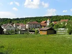 View from the south | |
 Flag  Coat of arms | |
 Řikonín Location in the Czech Republic | |
| Coordinates: 49°21′52″N 16°18′21″E / 49.36444°N 16.30583°E | |
| Country | |
| Region | South Moravian |
| District | Brno-Country |
| First mentioned | 1365 |
| Area | |
| • Total | 2.59 km2 (1.00 sq mi) |
| Elevation | 355 m (1,165 ft) |
| Population (2023-01-01)[1] | |
| • Total | 55 |
| • Density | 21/km2 (55/sq mi) |
| Time zone | UTC+1 (CET) |
| • Summer (DST) | UTC+2 (CEST) |
| Postal code | 594 51 |
| Website | www |
Řikonín is a municipality and village in Brno-Country District in the South Moravian Region of the Czech Republic. It has about 60 inhabitants.
Řikonín lies approximately 29 kilometres (18 mi) north-west of Brno and 158 km (98 mi) south-east of Prague.
Demographics
| Year | Pop. | ±% |
|---|---|---|
| 1869 | 111 | — |
| 1880 | 108 | −2.7% |
| 1890 | 98 | −9.3% |
| 1900 | 91 | −7.1% |
| 1910 | 80 | −12.1% |
| 1921 | 75 | −6.2% |
| 1930 | 75 | +0.0% |
| 1950 | 63 | −16.0% |
| 1961 | 63 | +0.0% |
| 1970 | 52 | −17.5% |
| 1980 | 43 | −17.3% |
| 1991 | 42 | −2.3% |
| 2001 | 41 | −2.4% |
| 2011 | 35 | −14.6% |
| 2021 | 52 | +48.6% |
| Source: Censuses[2][3] | ||
Gallery
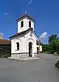 Chapel of Saint Giles
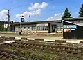 Train station
References
- ↑ "Population of Municipalities – 1 January 2023". Czech Statistical Office. 2023-05-23.
- ↑ "Historický lexikon obcí České republiky 1869–2011 – Okres Brno-venkov" (in Czech). Czech Statistical Office. 2015-12-21.
- ↑ "Population Census 2021: Population by sex". Public Database. Czech Statistical Office. 2021-03-27.
Wikimedia Commons has media related to Řikonín.
This article is issued from Wikipedia. The text is licensed under Creative Commons - Attribution - Sharealike. Additional terms may apply for the media files.