Běleč | |
|---|---|
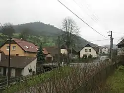 Centre of Běleč | |
 Flag  Coat of arms | |
 Běleč Location in the Czech Republic | |
| Coordinates: 49°26′2″N 16°22′59″E / 49.43389°N 16.38306°E | |
| Country | |
| Region | South Moravian |
| District | Brno-Country |
| First mentioned | 1447 |
| Area | |
| • Total | 4.03 km2 (1.56 sq mi) |
| Elevation | 406 m (1,332 ft) |
| Population (2023-01-01)[1] | |
| • Total | 211 |
| • Density | 52/km2 (140/sq mi) |
| Time zone | UTC+1 (CET) |
| • Summer (DST) | UTC+2 (CEST) |
| Postal code | 679 23 |
| Website | www |
Běleč is a municipality and village in Brno-Country District in the South Moravian Region of the Czech Republic. It has about 200 inhabitants.
Běleč lies approximately 31 kilometres (19 mi) north-west of Brno and 159 km (99 mi) south-east of Prague.
Administrative parts
The village of Křeptov is an administrative part of Běleč.
Demographics
| Year | Pop. | ±% |
|---|---|---|
| 1869 | 190 | — |
| 1880 | 247 | +30.0% |
| 1890 | 232 | −6.1% |
| 1900 | 237 | +2.2% |
| 1910 | 264 | +11.4% |
| 1921 | 286 | +8.3% |
| 1930 | 276 | −3.5% |
| 1950 | 309 | +12.0% |
| 1961 | 323 | +4.5% |
| 1970 | 277 | −14.2% |
| 1980 | 249 | −10.1% |
| 1991 | 218 | −12.4% |
| 2001 | 194 | −11.0% |
| 2011 | 186 | −4.1% |
| 2021 | 191 | +2.7% |
| Source: Censuses[2][3] | ||
References
- ↑ "Population of Municipalities – 1 January 2023". Czech Statistical Office. 2023-05-23.
- ↑ "Historický lexikon obcí České republiky 1869–2011 – Okres Brno-venkov" (in Czech). Czech Statistical Office. 2015-12-21.
- ↑ "Population Census 2021: Population by sex". Public Database. Czech Statistical Office. 2021-03-27.
Wikimedia Commons has media related to Běleč (Brno-Country District).
This article is issued from Wikipedia. The text is licensed under Creative Commons - Attribution - Sharealike. Additional terms may apply for the media files.