Kratochvilka | |
|---|---|
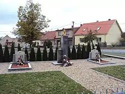 Memorial to the victims of the world wars | |
 Flag  Coat of arms | |
 Kratochvilka Location in the Czech Republic | |
| Coordinates: 49°9′24″N 16°22′35″E / 49.15667°N 16.37639°E | |
| Country | |
| Region | South Moravian |
| District | Brno-Country |
| Founded | 1783 |
| Area | |
| • Total | 1.50 km2 (0.58 sq mi) |
| Elevation | 385 m (1,263 ft) |
| Population (2023-01-01)[1] | |
| • Total | 483 |
| • Density | 320/km2 (830/sq mi) |
| Time zone | UTC+1 (CET) |
| • Summer (DST) | UTC+2 (CEST) |
| Postal codes | 664 91 |
| Website | www |
Kratochvilka is a municipality and village in Brno-Country District in the South Moravian Region of the Czech Republic. It has about 500 inhabitants.
Kratochvilka lies approximately 19 kilometres (12 mi) west of Brno and 175 km (109 mi) south-east of Prague.
Demographics
As of the 2021 census, the population is 466, up 4% from 445 in 2011.
| Year | Pop. | ±% |
|---|---|---|
| 1869 | 190 | — |
| 1880 | 209 | +10.0% |
| 1890 | 244 | +16.7% |
| 1900 | 360 | +47.5% |
| 1910 | 429 | +19.2% |
| 1921 | 482 | +12.4% |
| 1930 | 561 | +16.4% |
| 1950 | 586 | +4.5% |
| 1961 | 536 | −8.5% |
| 1970 | 518 | −3.4% |
| 1980 | 506 | −2.3% |
| 1991 | 436 | −13.8% |
| 2001 | 429 | −1.6% |
| 2011 | 445 | +3.7% |
| 2021 | 466 | +4.7% |
| Source: Censuses[2][3] | ||
References
- ↑ "Population of Municipalities – 1 January 2023". Czech Statistical Office. 2023-05-23.
- ↑ "Historický lexikon obcí České republiky 1869–2011 – Okres Brno-venkov" (in Czech). Czech Statistical Office. 2015-12-21. pp. 1–2.
- ↑ "Population Census 2021: Population by sex". Public Database. Czech Statistical Office. 2021-03-27.
Wikimedia Commons has media related to Kratochvilka.
This article is issued from Wikipedia. The text is licensed under Creative Commons - Attribution - Sharealike. Additional terms may apply for the media files.