Popůvky | |
|---|---|
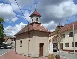 Chapel of Saint John of Nepomuk | |
.svg.png.webp) Flag  Coat of arms | |
 Popůvky Location in the Czech Republic | |
| Coordinates: 49°10′39″N 16°29′15″E / 49.17750°N 16.48750°E | |
| Country | |
| Region | South Moravian |
| District | Brno-Country |
| First mentioned | 1349 |
| Area | |
| • Total | 7.46 km2 (2.88 sq mi) |
| Elevation | 288 m (945 ft) |
| Population (2023-01-01)[1] | |
| • Total | 1,782 |
| • Density | 240/km2 (620/sq mi) |
| Time zone | UTC+1 (CET) |
| • Summer (DST) | UTC+2 (CEST) |
| Postal code | 664 41 |
| Website | www |
Popůvky is a municipality and village in Brno-Country District in the South Moravian Region of the Czech Republic. It has about 1,800 inhabitants.
Demographics
| Year | Pop. | ±% |
|---|---|---|
| 1869 | 237 | — |
| 1880 | 258 | +8.9% |
| 1890 | 282 | +9.3% |
| 1900 | 320 | +13.5% |
| 1910 | 364 | +13.7% |
| 1921 | 394 | +8.2% |
| 1930 | 537 | +36.3% |
| 1950 | 589 | +9.7% |
| 1961 | 615 | +4.4% |
| 1970 | 623 | +1.3% |
| 1980 | 584 | −6.3% |
| 1991 | 536 | −8.2% |
| 2001 | 599 | +11.8% |
| 2011 | 1,371 | +128.9% |
| 2021 | 1,798 | +31.1% |
| Source: Censuses[2][3] | ||
Transport
The D1 motorway goes through the centre of Popůvky.
References
- ↑ "Population of Municipalities – 1 January 2023". Czech Statistical Office. 2023-05-23.
- ↑ "Historický lexikon obcí České republiky 1869–2011 – Okres Brno-venkov" (in Czech). Czech Statistical Office. 2015-12-21. pp. 7–8.
- ↑ "Population Census 2021: Population by sex". Public Database. Czech Statistical Office. 2021-03-27.
Wikimedia Commons has media related to Popůvky (Brno-Country District).
This article is issued from Wikipedia. The text is licensed under Creative Commons - Attribution - Sharealike. Additional terms may apply for the media files.