Fuilla
Fullà | |
|---|---|
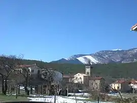 The church and surrounding buildings in winter | |
.svg.png.webp) Coat of arms | |
Location of Fuilla | |
 Fuilla  Fuilla | |
| Coordinates: 42°33′46″N 2°21′48″E / 42.5628°N 2.3633°E | |
| Country | France |
| Region | Occitania |
| Department | Pyrénées-Orientales |
| Arrondissement | Prades |
| Canton | Le Canigou |
| Government | |
| • Mayor (2020–2026) | Jean-François Laborde[1] |
| Area 1 | 9.69 km2 (3.74 sq mi) |
| Population | 434 |
| • Density | 45/km2 (120/sq mi) |
| Time zone | UTC+01:00 (CET) |
| • Summer (DST) | UTC+02:00 (CEST) |
| INSEE/Postal code | 66085 /66820 |
| Elevation | 430–1,171 m (1,411–3,842 ft) (avg. 547 m or 1,795 ft) |
| 1 French Land Register data, which excludes lakes, ponds, glaciers > 1 km2 (0.386 sq mi or 247 acres) and river estuaries. | |
Fuilla (French pronunciation: [fɥija] ⓘ; Catalan: Fullà) is a commune in the Pyrénées-Orientales department in southern France.
Geography
Fuilla is located in the canton of Le Canigou and in the arrondissement of Prades.

Map of Fuilla and its surrounding communes
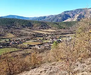
View across the central part of the commune, in the Rotja valley.
Population
| Year | Pop. | ±% p.a. |
|---|---|---|
| 1968 | 266 | — |
| 1975 | 233 | −1.87% |
| 1982 | 254 | +1.24% |
| 1990 | 297 | +1.97% |
| 1999 | 329 | +1.14% |
| 2007 | 365 | +1.31% |
| 2012 | 430 | +3.33% |
| 2017 | 448 | +0.82% |
| Source: INSEE[3] | ||
See also
References
- ↑ "Répertoire national des élus: les maires" (in French). data.gouv.fr, Plateforme ouverte des données publiques françaises. 13 September 2022.
- ↑ "Populations légales 2021". The National Institute of Statistics and Economic Studies. 28 December 2023.
- ↑ Population en historique depuis 1968, INSEE
Wikimedia Commons has media related to Fuilla.
This article is issued from Wikipedia. The text is licensed under Creative Commons - Attribution - Sharealike. Additional terms may apply for the media files.