La Llagonne
La Llaguna | |
|---|---|
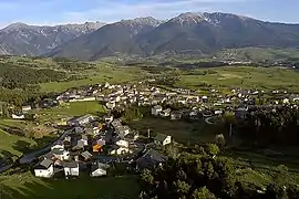 An aerial view of La Llagonne | |
 Coat of arms | |
Location of La Llagonne | |
 La Llagonne  La Llagonne | |
| Coordinates: 42°31′38″N 2°07′18″E / 42.5272°N 2.1217°E | |
| Country | France |
| Region | Occitania |
| Department | Pyrénées-Orientales |
| Arrondissement | Prades |
| Canton | Les Pyrénées catalanes |
| Intercommunality | Pyrénées Catalanes |
| Government | |
| • Mayor (2020–2026) | Jean-Pierre Astruch[1] |
| Area 1 | 23.09 km2 (8.92 sq mi) |
| Population | 218 |
| • Density | 9.4/km2 (24/sq mi) |
| Time zone | UTC+01:00 (CET) |
| • Summer (DST) | UTC+02:00 (CEST) |
| INSEE/Postal code | 66098 /66210 |
| Elevation | 1,546–2,196 m (5,072–7,205 ft) (avg. 1,657 m or 5,436 ft) |
| 1 French Land Register data, which excludes lakes, ponds, glaciers > 1 km2 (0.386 sq mi or 247 acres) and river estuaries. | |
La Llagonne (French: [la jagɔn] ⓘ; Catalan: La Llaguna) is a commune in the Pyrénées-Orientales department in southern France.
Geography
La Llagonne is located in the canton of Les Pyrénées catalanes and in the arrondissement of Prades.
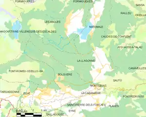
Map of La Llagonne and its surrounding communes
History
First time skiing in the Pyrénées happened on January 29, 1901 at La Llagonne.[3]
Population
| Year | Pop. | ±% p.a. |
|---|---|---|
| 1968 | 164 | — |
| 1975 | 138 | −2.44% |
| 1982 | 214 | +6.47% |
| 1990 | 243 | +1.60% |
| 1999 | 263 | +0.88% |
| 2007 | 274 | +0.51% |
| 2012 | 238 | −2.78% |
| 2017 | 219 | −1.65% |
| Source: INSEE[4] | ||
See also
References
- ↑ "Répertoire national des élus: les maires" (in French). data.gouv.fr, Plateforme ouverte des données publiques françaises. 13 September 2022.
- ↑ "Populations légales 2021". The National Institute of Statistics and Economic Studies. 28 December 2023.
- ↑ Cárdenas, Fabricio (2014). 66 petites histoires du Pays Catalan [66 Little Stories of Catalan Country] (in French). Perpignan: Ultima Necat. ISBN 978-2-36771-006-8. OCLC 893847466.
- ↑ Population en historique depuis 1968, INSEE
Wikimedia Commons has media related to La Llagonne.
This article is issued from Wikipedia. The text is licensed under Creative Commons - Attribution - Sharealike. Additional terms may apply for the media files.