Porté-Puymorens
Portè i Pimorent | |
|---|---|
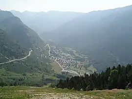 A view of Porté-Puymorens at the foot of Puig Carlit | |
Location of Porté-Puymorens | |
 Porté-Puymorens  Porté-Puymorens | |
| Coordinates: 42°32′57″N 1°49′57″E / 42.5492°N 1.8325°E | |
| Country | France |
| Region | Occitania |
| Department | Pyrénées-Orientales |
| Arrondissement | Prades |
| Canton | Les Pyrénées catalanes |
| Intercommunality | Pyrénées Cerdagne |
| Government | |
| • Mayor (2020–2026) | Philippe Maurisse[1] |
| Area 1 | 49.42 km2 (19.08 sq mi) |
| Population | 104 |
| • Density | 2.1/km2 (5.5/sq mi) |
| Time zone | UTC+01:00 (CET) |
| • Summer (DST) | UTC+02:00 (CEST) |
| INSEE/Postal code | 66147 /66760 |
| Elevation | 1,557–2,827 m (5,108–9,275 ft) (avg. 1,610 m or 5,280 ft) |
| 1 French Land Register data, which excludes lakes, ponds, glaciers > 1 km2 (0.386 sq mi or 247 acres) and river estuaries. | |
Porté-Puymorens (French pronunciation: [pɔʁte pɥimɔʁɛ̃s] ⓘ; Catalan: Portè) is a commune in the Pyrénées-Orientales department in southern France.
Geography
Porté-Puymorens is located in the canton of Les Pyrénées catalanes and in the arrondissement of Prades. Porté-Puymorens station has rail connections to Toulouse, Foix and Latour-de-Carol.

Map of Porté-Puymorens and its surrounding communes
Population
| Year | Pop. | ±% p.a. |
|---|---|---|
| 1968 | 108 | — |
| 1975 | 113 | +0.65% |
| 1982 | 119 | +0.74% |
| 1990 | 121 | +0.21% |
| 1999 | 147 | +2.19% |
| 2007 | 124 | −2.10% |
| 2012 | 134 | +1.56% |
| 2017 | 101 | −5.50% |
| Source: INSEE[3] | ||
See also
References
- ↑ "Répertoire national des élus: les maires". data.gouv.fr, Plateforme ouverte des données publiques françaises (in French). 2 December 2020.
- ↑ "Populations légales 2021". The National Institute of Statistics and Economic Studies. 28 December 2023.
- ↑ Population en historique depuis 1968, INSEE
Wikimedia Commons has media related to Porté-Puymorens.
This article is issued from Wikipedia. The text is licensed under Creative Commons - Attribution - Sharealike. Additional terms may apply for the media files.