Gigean | |
|---|---|
 Abbey St Félix de Montceau. | |
.svg.png.webp) Coat of arms | |
Location of Gigean | |
 Gigean  Gigean | |
| Coordinates: 43°30′01″N 3°42′42″E / 43.5003°N 3.7117°E | |
| Country | France |
| Region | Occitania |
| Department | Hérault |
| Arrondissement | Montpellier |
| Canton | Frontignan |
| Intercommunality | CA Sète Agglopôle Méditerranée |
| Government | |
| • Mayor (2020–2026) | Marcel Stoecklin[1] |
| Area 1 | 16.56 km2 (6.39 sq mi) |
| Population | 6,565 |
| • Density | 400/km2 (1,000/sq mi) |
| Time zone | UTC+01:00 (CET) |
| • Summer (DST) | UTC+02:00 (CEST) |
| INSEE/Postal code | 34113 /34770 |
| Elevation | 10–232 m (33–761 ft) (avg. 44 m or 144 ft) |
| 1 French Land Register data, which excludes lakes, ponds, glaciers > 1 km2 (0.386 sq mi or 247 acres) and river estuaries. | |
Gigean (French pronunciation: [ʒiʒɑ̃]; Occitan: Gijan) is a commune in the Hérault département in Occitanie in southern France.
Map
Geography
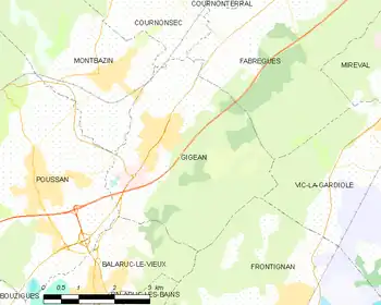
Gigean is bordered by the Étang de Thau to its west, the Gardiole hills to its south and by a wine growing plain, which runs from the Moure Hills to the edge of Montpellier.
Gigean is 18 km (11 mi) from Montpellier and 14 km (8.7 mi) from Sète.
The A9 autoroute exchange is 2 km (1.2 mi) south, which runs to the A75 33 km (21 mi) away at Clermont-l'Hérault.
The climate is Mediterranean: warm and dry in the summer, mild in the winter. Autumn is often marked by rain and heavy wind.
Neighboring communes
Poussan, Montbazin, Cournonsec, Fabrègues, Vic-la-Gardiole, Frontignan and Balaruc-le-Vieux.
Population
Its inhabitants are called Gigeannais
| Year | Pop. | ±% p.a. |
|---|---|---|
| 1968 | 1,847 | — |
| 1975 | 2,135 | +2.09% |
| 1982 | 2,021 | −0.78% |
| 1990 | 2,529 | +2.84% |
| 1999 | 3,552 | +3.85% |
| 2007 | 5,186 | +4.84% |
| 2012 | 5,957 | +2.81% |
| 2017 | 6,426 | +1.53% |
| Source: INSEE[3] | ||
Sights
- Saint Félix-de-Montceau: 13th century abbey, a listed monument historique since 1925, now in ruins,[4] situated on the Gardiole hills.
- Église Saint Genis: 13th century church.
See also
References
- ↑ "Répertoire national des élus: les maires" (in French). data.gouv.fr, Plateforme ouverte des données publiques françaises. 13 September 2022.
- ↑ "Populations légales 2021". The National Institute of Statistics and Economic Studies. 28 December 2023.
- ↑ Population en historique depuis 1968, INSEE
- ↑ Base Mérimée: Ancienne abbaye Saint-Félix-de-Montceau, Ministère français de la Culture. (in French)
External links
Wikimedia Commons has media related to Gigean.
- (in French) Official site
- (in French) "Gigean-village" Information about the commune
- (in French) Abbey
This article is issued from Wikipedia. The text is licensed under Creative Commons - Attribution - Sharealike. Additional terms may apply for the media files.