Hayrat | |
|---|---|
District and municipality | |
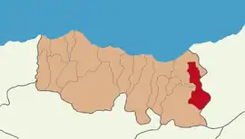
 Map showing Hayrat District in Trabzon Province | |
 Hayrat Location in Turkey | |
| Coordinates: 40°53′21″N 40°22′04″E / 40.88917°N 40.36778°E | |
| Country | Turkey |
| Province | Trabzon |
| Government | |
| • Mayor | Mehmet Nuhoğlu (AKP) |
| Area | 244 km2 (94 sq mi) |
| Population (2022)[1] | 7,667 |
| • Density | 31/km2 (81/sq mi) |
| Time zone | TRT (UTC+3) |
| Postal code | 61450 |
| Area code | 0462 |
| Climate | Cfa |
| Website | www |
Hayrat is a municipality and district of Trabzon Province, Turkey.[2] Its area is 244 km2,[3] and its population is 7,667 (2022).[1] The mayor is Mehmet Nuhoğlu (AKP).
History
During World War I, occupied by the Russians, Hayrat was freed from the occupation on 28 February 1918.
Composition
There are 35 neighbourhoods in Hayrat District:[4]
- Ağaçlı Düz
- Balaban
- Balaban Merkez
- Çağlayan
- Çamlıtepe
- Çaycılar
- Cumhuriyet
- Dağönü
- Dereyurt
- Fatih
- Geçitli
- Göksel
- Görgülü
- Gülderen Fatih
- Gülderen Merkez
- Hamzalı
- Hürriyet
- Kılavuz
- Köyceğiz
- Kurtuluş
- Merkez
- Meydanlı
- Onurlu
- Pazarönü
- Pınarca
- Sarmaşık
- Şehitli
- Şişli
- Taflancık
- Topaklı
- Yarlı
- Yeniköy
- Yenimahalle
- Yıldırımlar
- Yırca
References
- 1 2 "Address-based population registration system (ADNKS) results dated 31 December 2022, Favorite Reports" (XLS). TÜİK. Retrieved 19 September 2023.
- ↑ Büyükşehir İlçe Belediyesi, Turkey Civil Administration Departments Inventory. Retrieved 19 September 2023.
- ↑ "İl ve İlçe Yüz ölçümleri". General Directorate of Mapping. Retrieved 19 September 2023.
- ↑ Mahalle, Turkey Civil Administration Departments Inventory. Retrieved 19 September 2023.
External links
- District governor's official website (in Turkish)
This article is issued from Wikipedia. The text is licensed under Creative Commons - Attribution - Sharealike. Additional terms may apply for the media files.
