Yomra | |
|---|---|
District and municipality | |
 Map showing Yomra District in Trabzon Province | |
 Yomra Location in Turkey | |
| Coordinates: 40°57′32″N 39°50′49″E / 40.95889°N 39.84694°E | |
| Country | Turkey |
| Province | Trabzon |
| Government | |
| • Mayor | Mustafa Bıyık (İYİ) |
| Area | 200 km2 (80 sq mi) |
| Population (2022)[1] | 47,283 |
| • Density | 240/km2 (610/sq mi) |
| Time zone | TRT (UTC+3) |
| Postal code | 61250 |
| Area code | 0462 |
| Climate | Cfa |
| Website | www |
Yomra (Greek: Γέμουρα) is a municipality and district of Trabzon Province, Turkey.[2] Its area is 200 km2,[3] and its population is 47,283 (2022).[1] The town lies on the Black Sea coast, east of the city of Trabzon. The mayor is Mustafa Bıyık (Good Party).
Composition
There are 25 neighbourhoods in Yomra District:[4]
- Çamlıca
- Çamlıyurt
- Çınarlı
- Demirciler
- Gülyurdu
- Gürsel
- İkisu
- Kaşüstü
- Kayabaşı
- Kılıçlı
- Kıratlı
- Kömürcü
- Madenköy
- Namık Kemal
- Ocak
- Oymalı
- Özdil
- Pınarlı
- Sancak
- Şanlı
- Tandırlı
- Taşdelen
- Tepeköy
- Yenice
- Yokuşlu
References
- 1 2 "Address-based population registration system (ADNKS) results dated 31 December 2022, Favorite Reports" (XLS). TÜİK. Retrieved 19 September 2023.
- ↑ Büyükşehir İlçe Belediyesi, Turkey Civil Administration Departments Inventory. Retrieved 19 September 2023.
- ↑ "İl ve İlçe Yüz ölçümleri". General Directorate of Mapping. Retrieved 19 September 2023.
- ↑ Mahalle, Turkey Civil Administration Departments Inventory. Retrieved 19 September 2023.
External links
- District governor's official website (in Turkish)
- District municipality's official website (in Turkish)
Yomra in Trabzon Province of Turkey | |||||||||||||||||||||||||||
|---|---|---|---|---|---|---|---|---|---|---|---|---|---|---|---|---|---|---|---|---|---|---|---|---|---|---|---|
| Districts | 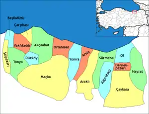 Districts of Trabzon | ||||||||||||||||||||||||||
| |||||||||||||||||||||||||||
Metropolitan municipalities are bolded. | |||||||||||||||||||||||||||
This article is issued from Wikipedia. The text is licensed under Creative Commons - Attribution - Sharealike. Additional terms may apply for the media files.