Camors
Kamorzh | |
|---|---|
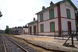
 The Lambel - Camors railway station | |
.svg.png.webp) Coat of arms | |
Location of Camors | |
 Camors  Camors | |
| Coordinates: 47°50′55″N 2°59′59″W / 47.8486°N 2.9997°W | |
| Country | France |
| Region | Brittany |
| Department | Morbihan |
| Arrondissement | Lorient |
| Canton | Pluvigner |
| Intercommunality | Auray Quiberon Terre Atlantique |
| Government | |
| • Mayor (2020–2026) | Claude Jarno[1] |
| Area 1 | 37.09 km2 (14.32 sq mi) |
| Population | 3,099 |
| • Density | 84/km2 (220/sq mi) |
| Time zone | UTC+01:00 (CET) |
| • Summer (DST) | UTC+02:00 (CEST) |
| INSEE/Postal code | 56031 /56330 |
| Elevation | 27–137 m (89–449 ft) |
| 1 French Land Register data, which excludes lakes, ponds, glaciers > 1 km2 (0.386 sq mi or 247 acres) and river estuaries. | |
Camors (French pronunciation: [kamɔʁ]; Breton: Kamorzh) is a commune in the Morbihan department of Brittany in north-western France.[3]
Geography
The village is situated in the heart of a forest-covered region called the Landes de Lanvaux. The village centre is located 24 km (15 mi) south of Pontivy, 28 km (17 mi) northwest of Vannes, and 29 km (18 mi) northeast of Lorient. With the River Tarun, its main tributary, the Ével forms the commune's northern border. The village centre is surrounded by the forest of Floranges and the national forest of Camors. Apart from the village centre, there are the village of Lambel-Camors and the village of Locoal-Camors and several hamlets.
Demographics
Inhabitants of Camors are called in French Camoriens.
|
| ||||||||||||||||||||||||||||||||||||||||||||||||||||||||||||||||||||||||||||||||||||||||||||||||||||||||||||||||||
| Source: EHESS[4] and INSEE (1968-2020)[5] | |||||||||||||||||||||||||||||||||||||||||||||||||||||||||||||||||||||||||||||||||||||||||||||||||||||||||||||||||||
Map
History
In the past, the inhabitants lived off the resources of the forest; they were clog makers, charcoal makers, sawyers, woodcutters...The last clogmaker in Morbihan lived in Camors.
Points of interest
See also
References
- ↑ "Maires du Morbihan" (PDF). Préfecture du Morbihan. 7 July 2020.
- ↑ "Populations légales 2021". The National Institute of Statistics and Economic Studies. 28 December 2023.
- ↑ INSEE commune file
- ↑ Des villages de Cassini aux communes d'aujourd'hui: Commune data sheet Camors, EHESS (in French).
- ↑ Population en historique depuis 1968, INSEE
External links
- Official site (in French)
- Base Mérimée: Search for heritage in the commune, Ministère français de la Culture. (in French)
- Mayors of Morbihan Association (in French)
