Roudouallec
Roudoualleg | |
|---|---|
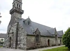 The parish church | |
Location of Roudouallec | |
 Roudouallec  Roudouallec | |
| Coordinates: 48°07′39″N 3°42′56″W / 48.1275°N 3.7156°W | |
| Country | France |
| Region | Brittany |
| Department | Morbihan |
| Arrondissement | Pontivy |
| Canton | Gourin |
| Intercommunality | Roi Morvan Communauté |
| Government | |
| • Mayor (2020–2026) | Paul Cozic[1] |
| Area 1 | 24.82 km2 (9.58 sq mi) |
| Population | 709 |
| • Density | 29/km2 (74/sq mi) |
| Time zone | UTC+01:00 (CET) |
| • Summer (DST) | UTC+02:00 (CEST) |
| INSEE/Postal code | 56199 /56110 |
| Elevation | 118–248 m (387–814 ft) |
| 1 French Land Register data, which excludes lakes, ponds, glaciers > 1 km2 (0.386 sq mi or 247 acres) and river estuaries. | |
Roudouallec (French pronunciation: [ʁudwalɛk]; Breton: Roudoualleg) is a commune in the Morbihan department of Brittany in north-western France.[3] Inhabitants of Roudouallec are called in French Roudouallecois.
Geography
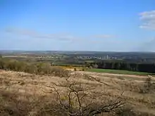
Roudouallec is located 32 km (20 mi) northeast of Quimper and 88 km (55 mi) northwest of Vannes. The village lies on the southern slope of the Montagnes Noires (french, Black mountains).
Neighboring communes
Roudouallec is border by Gourin to the east, by Guiscriff and Scaër to the south, by Leuhan and Saint-Goazec to the west and by Spézet to the north.
Map

Population
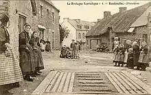
Roudouallec's population peaked at 1,656 in 1911 and declined to 705 in 2019. This represents a 57.4% decrease in total population since the peak census figure.
|
|
| |||||||||||||||||||||||||||||||||||||||||||||||||||||||||||||||||||||||||||||||||||||||||||||||||||||||||||||||||||||
| Source: EHESS[4] and INSEE (1968-2019)[5] | |||||||||||||||||||||||||||||||||||||||||||||||||||||||||||||||||||||||||||||||||||||||||||||||||||||||||||||||||||||||
History
The area around Roudouallac is represented on the Saint-Bélec slab, dating to the early Bronze Age and identified as the earliest known map that can be tied to a specific location.[6]
Nicolas Le Grand, tailor born in Roudouallec in 1852 emigrated in 1881 to the United States. He was followed by other inhabitants.
See also
- Communes of the Morbihan department
- Entry on sculptor of local war memorial Jean Joncourt
References
- ↑ "Maires du Morbihan" (PDF). Préfecture du Morbihan. 7 July 2020.
- ↑ "Populations légales 2021". The National Institute of Statistics and Economic Studies. 28 December 2023.
- ↑ INSEE commune file
- ↑ Des villages de Cassini aux communes d'aujourd'hui: Commune data sheet Roudouaallec, EHESS (in French).
- ↑ Population en historique de puis 1968, INSEE
- ↑ Jacobs, Frank (3 September 2021). "Europe's oldest map shows tiny Bronze Age kingdom". Big Think. Retrieved 22 March 2023.
External links
- Base Mérimée: Search for heritage in the commune, Ministère français de la Culture. (in French)
- Mayors of Morbihan Association (in French)