Champ-sur-Drac | |
|---|---|
 The tower of Champ-sur-Drac | |
 Coat of arms | |
Location of Champ-sur-Drac | |
 Champ-sur-Drac  Champ-sur-Drac | |
| Coordinates: 45°04′44″N 5°43′55″E / 45.0788°N 5.732°E | |
| Country | France |
| Region | Auvergne-Rhône-Alpes |
| Department | Isère |
| Arrondissement | Grenoble |
| Canton | Le Pont-de-Claix |
| Intercommunality | Grenoble-Alpes Métropole |
| Government | |
| • Mayor (2020–2026) | Francis Dietrich[1] |
| Area 1 | 8.92 km2 (3.44 sq mi) |
| Population | 3,339 |
| • Density | 370/km2 (970/sq mi) |
| Time zone | UTC+01:00 (CET) |
| • Summer (DST) | UTC+02:00 (CEST) |
| INSEE/Postal code | 38071 /38560 |
| Elevation | 269–1,281 m (883–4,203 ft) (avg. 319 m or 1,047 ft) |
| 1 French Land Register data, which excludes lakes, ponds, glaciers > 1 km2 (0.386 sq mi or 247 acres) and river estuaries. | |
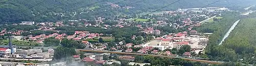
Champ-sur-Drac (French pronunciation: [ʃɑ̃ syʁ dʁak]) is a commune in the Isère department in southeastern France. It is situated at the foot of the Alps, at the confluence of the Romanche and the Drac. Its population was 3,007 in 2017. It is part of the Grenoble urban unit (agglomeration).[3]
Population
| Year | Pop. | ±% p.a. |
|---|---|---|
| 1968 | 2,316 | — |
| 1975 | 2,605 | +1.69% |
| 1982 | 3,094 | +2.49% |
| 1990 | 3,044 | −0.20% |
| 1999 | 3,260 | +0.76% |
| 2007 | 3,146 | −0.44% |
| 2012 | 3,097 | −0.31% |
| 2017 | 3,007 | −0.59% |
| Source: INSEE[4] | ||
Sister city
 Torviscosa, Italy (since 2006).
See also
References
- ↑ "Répertoire national des élus: les maires" (in French). data.gouv.fr, Plateforme ouverte des données publiques françaises. 13 September 2022.
- ↑ "Populations légales 2021". The National Institute of Statistics and Economic Studies. 28 December 2023.
- ↑ Unité urbaine 2020 de Grenoble (38701), INSEE
- ↑ Population en historique depuis 1968, INSEE
Wikimedia Commons has media related to Champ-sur-Drac.
This article is issued from Wikipedia. The text is licensed under Creative Commons - Attribution - Sharealike. Additional terms may apply for the media files.