Chardawol County
Persian: شهرستان چرداول | |
|---|---|
County | |
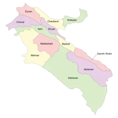
 Location of Chardavol County in Ilam province (top, yellow) | |
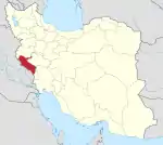
 Location of Ilam province in Iran | |
| Coordinates: 33°49′N 46°32′E / 33.817°N 46.533°E[1] | |
| Country | |
| Province | Ilam |
| Capital | Sarableh |
| Districts | Central, Asemanabad, Shabab, Zagros |
| Population (2016)[2] | |
| • Total | 57,381 |
| Time zone | UTC+3:30 (IRST) |
| Chardavol County can be found at GEOnet Names Server, at this link, by opening the Advanced Search box, entering "9205934" in the "Unique Feature Id" form, and clicking on "Search Database". | |
Chardawol County (Kurdish:Çerdawił,چەرداوڵ Persian: شهرستان چرداول) is in Ilam province, Iran. Its capital is the city of Sarableh.
At the 2006 census, the county's population was 73,422 in 15,087 households.[3] The following census in 2011 counted 72,167 people in 17,764 households.[4] The county was called Shirwan and Chardawol (شهرستان شیروان و چرداول) until 30 June 2013.[5]
At the 2016 census, the county's population was 57,381 in 15,867 households,[2] by which time Shirvan District had been separated from the county in the establishment of Sirvan County.[6] Additionally, Shabab Rural District had been separated from the Central District in the establishment of Shabab District, and Bijnavand Rural District in the establishment of Zagros District.[7]
Administrative divisions
The population history and structural changes of Chardavol County's administrative divisions over three consecutive censuses are shown in the following table. The latest census shows four districts, seven rural districts, and five cities.[2]
After the census, Asemanabad Rural District and the city of Asemanabad were separated from the Central District in the establishment of Asemanabad District. At the same time, Halehsam Rural District was established in the Central District.[8]
In 2018, Holeylan District was separated from the county in the establishment of Holeylan County.[9]
| Administrative Divisions | 2006[3] | 2011[4] | 2016[2] |
|---|---|---|---|
| Central District | 41,034 | 41,469 | 24,568 |
| Asemanabad RD | 6,411 | 6,275 | 5,895 |
| Bijnavand RD | 8,017 | 7,327 | |
| Halehsam RD1 | |||
| Shabab RD | 11,004 | 11,011 | |
| Asemanabad (city) | 5,899 | 5,889 | 6,280 |
| Sarableh (city) | 9,703 | 10,967 | 12,393 |
| Asemanabad District1 | |||
| Asemanabad RD | |||
| Kol Kol RD1 | |||
| Asemanabad (city) | |||
| Holeylan District2 | 15,191 | 14,793 | 15,276 |
| Holeylan RD | 12,069 | 10,791 | 10,634 |
| Zardalan RD | 2,518 | 2,527 | 2,514 |
| Towhid (city) | 604 | 1,475 | 2,128 |
| Shabab District | 11,135 | ||
| Shabab RD | 3,063 | ||
| Zanjireh RD | 3,984 | ||
| Shabab (city) | 4,088 | ||
| Shirvan District3 | 17,197 | 15,855 | |
| Karezan RD | 4,593 | 4,345 | |
| Lumar RD | 6,223 | 5,157 | |
| Zangvan RD | 3,679 | 3,695 | |
| Lumar (city) | 2,702 | 2,658 | |
| Zagros District | 6,395 | ||
| Bijnavand RD | 4,194 | ||
| Qaleh RD | 1,937 | ||
| Balavah (city) | 264 | ||
| Total | 73,422 | 72,167 | 57,381 |
| RD: Rural District 1Established after the 2016 census[8] 2Became a part of Holeylan County[9] 3Became a part of Sirvan County[6] | |||
References
- ↑ OpenStreetMap contributors (2 June 2023). "Chardavol County" (Map). OpenStreetMap. Retrieved 2 June 2023.
- 1 2 3 4 "Census of the Islamic Republic of Iran, 1395 (2016)". AMAR (in Persian). The Statistical Center of Iran. p. 16. Archived from the original (Excel) on 1 November 2020. Retrieved 19 December 2022.
- 1 2 "Census of the Islamic Republic of Iran, 1385 (2006)". AMAR (in Persian). The Statistical Center of Iran. p. 16. Archived from the original (Excel) on 20 September 2011. Retrieved 25 September 2022.
- 1 2 "Census of the Islamic Republic of Iran, 1390 (2011)" (Excel). Iran Data Portal (in Persian). The Statistical Center of Iran. p. 16. Retrieved 19 December 2022.
- ↑ Rahimi, Mohammad Reza (7 July 2013). "With the approval of the government board: The counties of Fardis, Badreh and Balaveh were added to the map of country divisions". Mehr News (in Persian). Ministry of Interior, Board of Ministers. Archived from the original on 24 March 2023. Retrieved 11 November 2023.
- 1 2 Rahimi, Mohammadreza (6 October 2012). "With some changes in the map of country divisions: Sirvan County was added to the map of country divisions". DOLAT (in Persian). Ministry of Interior, Council of Ministers. Archived from the original on 1 December 2017. Retrieved 11 November 2023.
- ↑ Rahimi, Mohammad Reza (7 July 2013). "With some changes in the geography map of Alborz and Ilam provinces: The counties of Fardis and Badreh and the city of Balavah were added to the map of the country's divisions". DOLAT (in Persian). Ministry of Interior, Board of Ministers. Archived from the original on 10 January 2017. Retrieved 11 November 2023.
- 1 2 Mokhbar, Mohammad (19 May 1402). "Approval letter regarding country divisions of Chardavol County of Ilam province". Laws and Regulations Portal of Iran (in Persian). Ministry of Interior, Board of Ministers. Archived from the original on 9 May 2023. Retrieved 3 June 2023.
- 1 2 Janhangiri, Ishaq (26 January 2018). "Approval letter regarding the country divisions of Ilam province". Islamic Parliament Research Center of the Islamic Republic of Iran (in Persian). Ministry of Interior, Council of Ministers. Archived from the original on 16 January 2020. Retrieved 3 June 2023.
