Fleuré | |
|---|---|
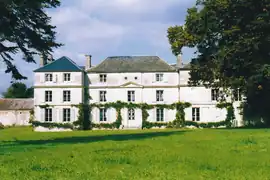 The chateau in Fleuré | |
Location of Fleuré | |
 Fleuré  Fleuré | |
| Coordinates: 48°41′29″N 0°03′20″W / 48.6914°N 0.0556°W | |
| Country | France |
| Region | Normandy |
| Department | Orne |
| Arrondissement | Argentan |
| Canton | Magny-le-Désert |
| Intercommunality | Argentan Intercom |
| Government | |
| • Mayor (2020–2026) | Thierry Clérembaux[1] |
| Area 1 | 11.8 km2 (4.6 sq mi) |
| Population | 202 |
| • Density | 17/km2 (44/sq mi) |
| Time zone | UTC+01:00 (CET) |
| • Summer (DST) | UTC+02:00 (CEST) |
| INSEE/Postal code | 61170 /61200 |
| Elevation | 156–265 m (512–869 ft) (avg. 164 m or 538 ft) |
| 1 French Land Register data, which excludes lakes, ponds, glaciers > 1 km2 (0.386 sq mi or 247 acres) and river estuaries. | |
Fleuré (French pronunciation: [flœʁe] ⓘ) is a commune in the Orne department in north-western France.
Geography
The commune is made up of the following collection of villages and hamlets, Fleuriel and Fleuré.[3]
It is 1,180 hectares (4.6 sq mi) in size. The highest point in the commune is 165 metres (541 ft).[4]
The Etangs stream, Marais de Fleuriel stream and the Bel Usse stream flow through the commune.[4]
Neighbouring communes[3] | ||||||||||||||||
|---|---|---|---|---|---|---|---|---|---|---|---|---|---|---|---|---|
| ||||||||||||||||
Notable buildings and places
- Stèle Étienne Panthou is a memorial remembering where a French Resistance fighter, Étienne Panthou, and an unknown person were executed in June 1944.[5]
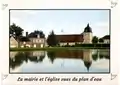 The Mayors office and Church
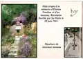 Stèle Étienne Panthou
See also
References
- ↑ "Répertoire national des élus: les maires" (in French). data.gouv.fr, Plateforme ouverte des données publiques françaises. 13 September 2022.
- ↑ "Populations légales 2021". The National Institute of Statistics and Economic Studies. 28 December 2023.
- 1 2 "Fleuré · 61200, France". Fleuré · 61200, France.
- 1 2 "Mairie de Fleuré et sa commune (61200) (Orne)". Annuaire-Mairie. 4 September 2023.
- ↑ "Fleuré. Un hommage à deux résistants fusillés il y a 78 ans". alencon.maville.com.
Wikimedia Commons has media related to Fleuré (Orne).
This article is issued from Wikipedia. The text is licensed under Creative Commons - Attribution - Sharealike. Additional terms may apply for the media files.