La Chapelle-près-Sées | |
|---|---|
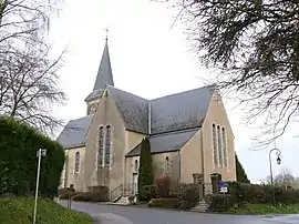 The church in La Chapelle-près-Sées | |
Location of La Chapelle-près-Sées | |
 La Chapelle-près-Sées  La Chapelle-près-Sées | |
| Coordinates: 48°34′17″N 0°09′45″E / 48.5714°N 0.1625°E | |
| Country | France |
| Region | Normandy |
| Department | Orne |
| Arrondissement | Alençon |
| Canton | Sées |
| Intercommunality | Sources de l'Orne |
| Government | |
| • Mayor (2020–2026) | Jean-Pierre Baëlde[1] |
| Area 1 | 9.95 km2 (3.84 sq mi) |
| Population | 475 |
| • Density | 48/km2 (120/sq mi) |
| Time zone | UTC+01:00 (CET) |
| • Summer (DST) | UTC+02:00 (CEST) |
| INSEE/Postal code | 61098 /61500 |
| Elevation | 168–260 m (551–853 ft) (avg. 200 m or 660 ft) |
| 1 French Land Register data, which excludes lakes, ponds, glaciers > 1 km2 (0.386 sq mi or 247 acres) and river estuaries. | |
La Chapelle-près-Sées (French pronunciation: [la ʃapɛl pʁɛ se] ⓘ, literally La Chapelle near Sées) is a commune in the Orne department in north-western France.
Notable buildings and places
National heritage sites
- Markers of Forêt d'Écouves a set of 80 markers positioned in the 18th century that mark the boundaries of the forest, they were registered as a Monument historique in 1987.[3]
See also
References
- ↑ "Répertoire national des élus: les maires". data.gouv.fr, Plateforme ouverte des données publiques françaises (in French). 9 August 2021.
- ↑ "Populations légales 2021". The National Institute of Statistics and Economic Studies. 28 December 2023.
- ↑ "80 bornes de la forêt d'Ecouves (également sur communes de Le Bouillon, La Chapelle-près-Sées, La Ferrière-Béchet, Fontenai-les-Louvets, La Lande-de-Goult, Radon, Rouperroux, Saint-Didier-sous-Ecouves, Saint-Gervais-du-Perron, Tanville et Vingt-Hanap..." monumentum.fr.
Wikimedia Commons has media related to La Chapelle-près-Sées.
This article is issued from Wikipedia. The text is licensed under Creative Commons - Attribution - Sharealike. Additional terms may apply for the media files.