Roiville | |
|---|---|
 | |
Location of Roiville | |
 Roiville  Roiville | |
| Coordinates: 48°52′51″N 0°14′09″E / 48.8808°N 0.2358°E | |
| Country | France |
| Region | Normandy |
| Department | Orne |
| Arrondissement | Mortagne-au-Perche |
| Canton | Vimoutiers |
| Intercommunality | Vallées d'Auge et du Merlerault |
| Government | |
| • Mayor (2020–2026) | Yvette Férey[1] |
| Area 1 | 8.18 km2 (3.16 sq mi) |
| Population | 134 |
| • Density | 16/km2 (42/sq mi) |
| Time zone | UTC+01:00 (CET) |
| • Summer (DST) | UTC+02:00 (CEST) |
| INSEE/Postal code | 61351 /61120 |
| Elevation | 118–245 m (387–804 ft) (avg. 180 m or 590 ft) |
| 1 French Land Register data, which excludes lakes, ponds, glaciers > 1 km2 (0.386 sq mi or 247 acres) and river estuaries. | |
Roiville (French pronunciation: [ʁwavil] ⓘ) is a commune in the Orne department in north-western France.
Geography
The River Vie runs through the commune in addition to two streams, the Fontaine de la Motte & the Valame.[3]
Neighbouring communes[4] | |
|---|---|
Notable buildings and places
National heritage sites
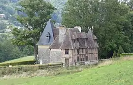
Manor of Mesnil is a 16th centaury Manor house, classified as a Monument historique in 1981.[5]
See also
References
- ↑ "Répertoire national des élus: les maires" (in French). data.gouv.fr, Plateforme ouverte des données publiques françaises. 13 September 2022.
- ↑ "Populations légales 2021". The National Institute of Statistics and Economic Studies. 28 December 2023.
- ↑ "Mairie de Roiville et sa commune (61120)". Annuaire-Mairie. 26 April 2023.
- ↑ "Roiville · 61120, France". Roiville · 61120, France.
- ↑ "Manoir du Mesnil à Roiville - PA00110904". monumentum.fr.
Wikimedia Commons has media related to Roiville.
This article is issued from Wikipedia. The text is licensed under Creative Commons - Attribution - Sharealike. Additional terms may apply for the media files.