Maumusson-Laguian | |
|---|---|
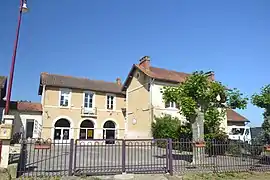 The town hall in Maumusson-Laguian | |
Location of Maumusson-Laguian | |
 Maumusson-Laguian  Maumusson-Laguian | |
| Coordinates: 43°36′31″N 0°05′51″W / 43.6087°N 0.0976°W | |
| Country | France |
| Region | Occitania |
| Department | Gers |
| Arrondissement | Mirande |
| Canton | Adour-Gersoise |
| Government | |
| • Mayor (2020–2026) | Guy Capmartin[1] |
| Area 1 | 9.30 km2 (3.59 sq mi) |
| Population | 148 |
| • Density | 16/km2 (41/sq mi) |
| Time zone | UTC+01:00 (CET) |
| • Summer (DST) | UTC+02:00 (CEST) |
| INSEE/Postal code | 32245 /32400 |
| Elevation | 112–184 m (367–604 ft) (avg. 145 m or 476 ft) |
| 1 French Land Register data, which excludes lakes, ponds, glaciers > 1 km2 (0.386 sq mi or 247 acres) and river estuaries. | |
Maumusson-Laguian (French pronunciation: [momysɔ̃ laɡjɑ̃]; Occitan: Maumusson e Laguian) is a commune in the Gers department in southwestern France.
Geography
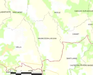
Maumusson-Lagui and its surrounding communes
Population
| Year | Pop. | ±% |
|---|---|---|
| 1962 | 240 | — |
| 1968 | 202 | −15.8% |
| 1975 | 182 | −9.9% |
| 1982 | 174 | −4.4% |
| 1990 | 163 | −6.3% |
| 1999 | 165 | +1.2% |
| 2008 | 155 | −6.1% |
See also
References
- ↑ "Répertoire national des élus: les maires". data.gouv.fr, Plateforme ouverte des données publiques françaises (in French). 2 December 2020.
- ↑ "Populations légales 2021". The National Institute of Statistics and Economic Studies. 28 December 2023.
Wikimedia Commons has media related to Maumusson-Laguian.
This article is issued from Wikipedia. The text is licensed under Creative Commons - Attribution - Sharealike. Additional terms may apply for the media files.