Saint-Michel | |
|---|---|
_8.jpg.webp) The town hall in Saint-Michel | |
Location of Saint-Michel | |
 Saint-Michel  Saint-Michel | |
| Coordinates: 43°25′48″N 0°24′56″E / 43.43°N 0.4156°E | |
| Country | France |
| Region | Occitania |
| Department | Gers |
| Arrondissement | Mirande |
| Canton | Mirande-Astarac |
| Government | |
| • Mayor (2020–2026) | Fabien Gouzenne[1] |
| Area 1 | 16.56 km2 (6.39 sq mi) |
| Population | 242 |
| • Density | 15/km2 (38/sq mi) |
| Time zone | UTC+01:00 (CET) |
| • Summer (DST) | UTC+02:00 (CEST) |
| INSEE/Postal code | 32397 /32300 |
| Elevation | 168–286 m (551–938 ft) (avg. 120 m or 390 ft) |
| 1 French Land Register data, which excludes lakes, ponds, glaciers > 1 km2 (0.386 sq mi or 247 acres) and river estuaries. | |
Saint-Michel (French pronunciation: [sɛ̃ miʃɛl] ⓘ; Gascon: Sent Miquèu) is a commune in the Gers department in southwestern France.
Geography
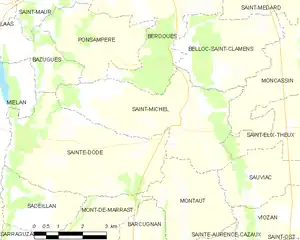
Saint-Michel and its surrounding communes
Population
| Year | Pop. | ±% |
|---|---|---|
| 1962 | 351 | — |
| 1968 | 373 | +6.3% |
| 1975 | 353 | −5.4% |
| 1982 | 316 | −10.5% |
| 1990 | 276 | −12.7% |
| 1999 | 241 | −12.7% |
| 2008 | 262 | +8.7% |
See also
References
- ↑ "Répertoire national des élus: les maires". data.gouv.fr, Plateforme ouverte des données publiques françaises (in French). 9 August 2021.
- ↑ "Populations légales 2021". The National Institute of Statistics and Economic Studies. 28 December 2023.
Wikimedia Commons has media related to Saint-Michel (Gers).
This article is issued from Wikipedia. The text is licensed under Creative Commons - Attribution - Sharealike. Additional terms may apply for the media files.