Sainte-Radegonde | |
|---|---|
Location of Sainte-Radegonde | |
 Sainte-Radegonde  Sainte-Radegonde | |
| Coordinates: 43°50′24″N 0°35′20″E / 43.84°N 0.5889°E | |
| Country | France |
| Region | Occitania |
| Department | Gers |
| Arrondissement | Condom |
| Canton | Fleurance-Lomagne |
| Intercommunality | Lomagne Gersoise |
| Government | |
| • Mayor (2020–2026) | Francis Barella[1] |
| Area 1 | 9.82 km2 (3.79 sq mi) |
| Population | 173 |
| • Density | 18/km2 (46/sq mi) |
| Time zone | UTC+01:00 (CET) |
| • Summer (DST) | UTC+02:00 (CEST) |
| INSEE/Postal code | 32405 /32500 |
| Elevation | 97–181 m (318–594 ft) (avg. 132 m or 433 ft) |
| 1 French Land Register data, which excludes lakes, ponds, glaciers > 1 km2 (0.386 sq mi or 247 acres) and river estuaries. | |
Sainte-Radegonde (French pronunciation: [sɛ̃t ʁadɡɔ̃d]; Occitan: Senta Regonda) is a commune in the Gers department in southwestern France.
Geography
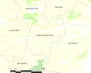
Sainte-Radegonde and its surrounding communes
Population
| Year | Pop. | ±% |
|---|---|---|
| 1962 | 180 | — |
| 1968 | 180 | +0.0% |
| 1975 | 160 | −11.1% |
| 1982 | 146 | −8.8% |
| 1990 | 155 | +6.2% |
| 1999 | 170 | +9.7% |
| 2008 | 187 | +10.0% |
See also
References
- ↑ "Répertoire national des élus: les maires". data.gouv.fr, Plateforme ouverte des données publiques françaises (in French). 2 December 2020.
- ↑ "Populations légales 2021". The National Institute of Statistics and Economic Studies. 28 December 2023.
Wikimedia Commons has media related to Sainte-Radegonde (Gers).
This article is issued from Wikipedia. The text is licensed under Creative Commons - Attribution - Sharealike. Additional terms may apply for the media files.