Monlezun-d'Armagnac | |
|---|---|
Location of Monlezun-d'Armagnac | |
 Monlezun-d'Armagnac  Monlezun-d'Armagnac | |
| Coordinates: 43°49′32″N 0°08′52″W / 43.8256°N 0.1478°W | |
| Country | France |
| Region | Occitania |
| Department | Gers |
| Arrondissement | Condom |
| Canton | Grand-Bas-Armagnac |
| Intercommunality | Bas-Armagnac |
| Government | |
| • Mayor (2020–2026) | Philippe Sauques[1] |
| Area 1 | 6.48 km2 (2.50 sq mi) |
| Population | 194 |
| • Density | 30/km2 (78/sq mi) |
| Time zone | UTC+01:00 (CET) |
| • Summer (DST) | UTC+02:00 (CEST) |
| INSEE/Postal code | 32274 /32240 |
| Elevation | 70–126 m (230–413 ft) (avg. 120 m or 390 ft) |
| 1 French Land Register data, which excludes lakes, ponds, glaciers > 1 km2 (0.386 sq mi or 247 acres) and river estuaries. | |
Monlezun-d'Armagnac (French pronunciation: [mɔ̃ləzœ̃ daʁmaɲak], literally Monlezun of Armagnac; Gascon: Montlasun d'Armanhac) is a commune in the Gers department in southwestern France.
Geography
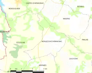
Monlezun-d'Armagnac and its surrounding communes
Population
| Year | Pop. | ±% |
|---|---|---|
| 1962 | 280 | — |
| 1968 | 263 | −6.1% |
| 1975 | 239 | −9.1% |
| 1982 | 259 | +8.4% |
| 1990 | 235 | −9.3% |
| 1999 | 205 | −12.8% |
| 2008 | 189 | −7.8% |
See also
References
- ↑ "Répertoire national des élus: les maires". data.gouv.fr, Plateforme ouverte des données publiques françaises (in French). 2 December 2020.
- ↑ "Populations légales 2021". The National Institute of Statistics and Economic Studies. 28 December 2023.
Wikimedia Commons has media related to Monlezun-d'Armagnac.
This article is issued from Wikipedia. The text is licensed under Creative Commons - Attribution - Sharealike. Additional terms may apply for the media files.