Saint-Ange-et-Torçay | |
|---|---|
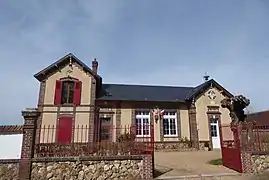 The town hall and school in Saint-Ange-et-Torçay | |
.svg.png.webp) Coat of arms | |
Location of Saint-Ange-et-Torçay | |
 Saint-Ange-et-Torçay  Saint-Ange-et-Torçay | |
| Coordinates: 48°38′18″N 1°13′34″E / 48.6383°N 1.2261°E | |
| Country | France |
| Region | Centre-Val de Loire |
| Department | Eure-et-Loir |
| Arrondissement | Dreux |
| Canton | Saint-Lubin-des-Joncherets |
| Intercommunality | CA Pays de Dreux |
| Government | |
| • Mayor (2020–2026) | Dominique Lubow[1] |
| Area 1 | 16.61 km2 (6.41 sq mi) |
| Population | 285 |
| • Density | 17/km2 (44/sq mi) |
| Time zone | UTC+01:00 (CET) |
| • Summer (DST) | UTC+02:00 (CEST) |
| INSEE/Postal code | 28323 /28170 |
| Elevation | 125–180 m (410–591 ft) (avg. 160 m or 520 ft) |
| 1 French Land Register data, which excludes lakes, ponds, glaciers > 1 km2 (0.386 sq mi or 247 acres) and river estuaries. | |
Saint-Ange-et-Torçay (French pronunciation: [sɛ̃.t‿ɑ̃ʒ e tɔʁsɛ]) is a commune in the Eure-et-Loir department in northern France.
Population
| Year | Pop. | ±% |
|---|---|---|
| 1962 | 203 | — |
| 1968 | 219 | +7.9% |
| 1975 | 210 | −4.1% |
| 1982 | 224 | +6.7% |
| 1990 | 243 | +8.5% |
| 1999 | 277 | +14.0% |
| 2008 | 275 | −0.7% |
See also
References
- ↑ "Répertoire national des élus: les maires" (in French). data.gouv.fr, Plateforme ouverte des données publiques françaises. 4 May 2022.
- ↑ "Populations légales 2021". The National Institute of Statistics and Economic Studies. 28 December 2023.
Wikimedia Commons has media related to Saint-Ange-et-Torçay.
This article is issued from Wikipedia. The text is licensed under Creative Commons - Attribution - Sharealike. Additional terms may apply for the media files.