Číhaň | |
|---|---|
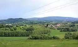 View from the northwest | |
 Flag  Coat of arms | |
 Číhaň Location in the Czech Republic | |
| Coordinates: 49°20′33″N 13°25′33″E / 49.34250°N 13.42583°E | |
| Country | |
| Region | Plzeň |
| District | Klatovy |
| First mentioned | 1552 |
| Area | |
| • Total | 8.52 km2 (3.29 sq mi) |
| Elevation | 593 m (1,946 ft) |
| Population (2023-01-01)[1] | |
| • Total | 218 |
| • Density | 26/km2 (66/sq mi) |
| Time zone | UTC+1 (CET) |
| • Summer (DST) | UTC+2 (CEST) |
| Postal code | 341 42 |
| Website | www |
Číhaň is a municipality and village in Klatovy District in the Plzeň Region of the Czech Republic. It has about 200 inhabitants.
Číhaň lies approximately 13 kilometres (8 mi) south-east of Klatovy, 46 km (29 mi) south of Plzeň, and 110 km (68 mi) south-west of Prague.
Administrative parts
Villages of Nový Dvůr and Plánička are administrative parts of Číhaň.
References
Wikimedia Commons has media related to Číhaň.
This article is issued from Wikipedia. The text is licensed under Creative Commons - Attribution - Sharealike. Additional terms may apply for the media files.