Prášily | |
|---|---|
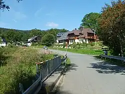
 Entrance to Prášily from the direction of Srní | |
 Flag  Coat of arms | |
 Prášily Location in the Czech Republic | |
| Coordinates: 49°6′19″N 13°22′41″E / 49.10528°N 13.37806°E | |
| Country | |
| Region | Plzeň |
| District | Klatovy |
| Founded | 1732 |
| Area | |
| • Total | 112.33 km2 (43.37 sq mi) |
| Elevation | 880 m (2,890 ft) |
| Population (2023-01-01)[1] | |
| • Total | 154 |
| • Density | 1.4/km2 (3.6/sq mi) |
| Time zone | UTC+1 (CET) |
| • Summer (DST) | UTC+2 (CEST) |
| Postal code | 342 01 |
| Website | www |
Prášily (German: Stubenbach) is a municipality and village in Klatovy District in the Plzeň Region of the Czech Republic. It has about 200 inhabitants.
Administrative parts
The village of Nová Hůrka is an administrative part of Prášily.
Geography
Prášily is located about 32 kilometres (20 mi) south of Klatovy and 70 km (43 mi) south of Plzeň. It border Germany in the southwest. It lies in the Bohemian Forest and within the Šumava National Park. The highest point is the Plesná mountain at 1,338 m (4,390 ft) above sea level. The Křemelná River flows through the municipality. A small but notable body of water is Lake Laka, one of few natural lakes in the Czech Republic.
With an area of 112.33 km2, Prášily is the largest municipality in the country without the town status by size, even though most of Prášily's territory is covered by forests.[2]
History
The first written mention of Myslív is from 1732.[3] In 1749, Lorenz Gattermayer bought the area from Countess Mansfeld and founded here two glassworks. After the Seven Years' War, Gattermayer had to sell Prášily due to debts. The new owners were the Kinsky family, who leased the glassworks to the Abele family. During their era, tens of thousands of mirrors were produced in Prášily and the village experienced the greatest development. The school was opened in 1787 and the construction of the church began in 1793.[4]
In the early 1820s, glass factories disappeared due to competition. Lumberjacks moved into the abandoned houses. A paper mill was established in the buildings of the glass grinding mills in 1918, but it was destroyed by fire in 1933. Before World War I, the area was acquired by the Schwarzenberg family, who owned it until 1930.[4]
After World War II, the German-speaking population was expelled.
Demographics
|
|
| ||||||||||||||||||||||||||||||||||||||||||||||||||||||
| Source: Censuses[5][6] | ||||||||||||||||||||||||||||||||||||||||||||||||||||||||
Sights
.jpg.webp)
The main landmark of Prášily was the Church of Saint Procopius. It was built in the Neoclassical style in 1802–1803 and was demolished in 1978. Although it was demolished, its remains are protected as a cultural monuments.[7]
In Prášily is a freely accessible botanical garden with more than 5,000 species of plants. It covers an area of 1.5 ha (3.7 acres) and is the highest botanical garden in the country.[8]
On Poledník Hill (1,315 m (4,314 ft) above sea level) is the eponymous observation tower. It was created by the reconstruction of a military building and was opened in 1998. It is 37 m (121 ft) high and, due to the climatic conditions, is only accessible in the summer season.[9]
Notable people
- Gunther of Bohemia (c. 955–1045), Catholic hermit and diplomat; died in the hermitage on Březník mountain
Gallery
.JPG.webp) Memorial of villages destroyed by Czechoslovak army in the 1950s
Memorial of villages destroyed by Czechoslovak army in the 1950s Remnants of the Church of Saint Procopius
%252C_z%C3%A1stavba.jpg.webp) The village of Nová Hůrka
The village of Nová Hůrka
References
- ↑ "Population of Municipalities – 1 January 2023". Czech Statistical Office. 2023-05-23.
- ↑ Hejna, Petr (2017-10-23). "Šumavské Prášily oplývají četnými zajímavostmi i drží několik prvenství". Novinky.cz (in Czech). Retrieved 2023-07-06.
- ↑ "Základní údaje" (in Czech). Obec Prášily. Retrieved 2023-07-06.
- 1 2 "Historie Prášil" (in Czech). Obec Prášily. Retrieved 2023-12-29.
- ↑ "Historický lexikon obcí České republiky 1869–2011 – Okres Klatovy" (in Czech). Czech Statistical Office. 2015-12-21. pp. 23–24.
- ↑ "Population Census 2021: Population by sex". Public Database. Czech Statistical Office. 2021-03-27.
- ↑ "Kostel sv. Prokopa, archeologické stopy" (in Czech). National Heritage Institute. Retrieved 2023-07-06.
- ↑ "Botanická zahrada" (in Czech). Prášilský ráj. Retrieved 2023-07-06.
- ↑ "Rozhledna Poledník – pohled na Šumavu shora" (in Czech). CzechTourism. Retrieved 2023-07-06.