Dešenice | |
|---|---|
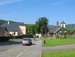 Former fort (left) and the Church of Saint Nicholas (right) | |
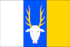 Flag 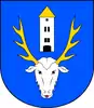 Coat of arms | |
 Dešenice Location in the Czech Republic | |
| Coordinates: 49°16′27″N 13°10′17″E / 49.27417°N 13.17139°E | |
| Country | |
| Region | Plzeň |
| District | Klatovy |
| First mentioned | 1200 |
| Area | |
| • Total | 31.38 km2 (12.12 sq mi) |
| Elevation | 505 m (1,657 ft) |
| Population (2023-01-01)[1] | |
| • Total | 696 |
| • Density | 22/km2 (57/sq mi) |
| Time zone | UTC+1 (CET) |
| • Summer (DST) | UTC+2 (CEST) |
| Postal codes | 340 21, 340 22 |
| Website | www |
Dešenice (German: Deschenitz) is a market town in Klatovy District in the Plzeň Region of the Czech Republic. It has about 700 inhabitants.
Dešenice lies approximately 16 kilometres (10 mi) south-west of Klatovy, 55 km (34 mi) south of Plzeň, and 128 km (80 mi) south-west of Prague.
Administrative parts
Villages of Datelov, Děpoltice, Divišovice, Matějovice, Městiště, Milence, Oldřichovice and Žiznětice are administrative parts of Dešenice.
References
Wikimedia Commons has media related to Dešenice.
This article is issued from Wikipedia. The text is licensed under Creative Commons - Attribution - Sharealike. Additional terms may apply for the media files.