Křenice | |
|---|---|
.jpg.webp) Centre of Křenice | |
 Flag  Coat of arms | |
 Křenice Location in the Czech Republic | |
| Coordinates: 49°30′10″N 13°12′1″E / 49.50278°N 13.20028°E | |
| Country | |
| Region | Plzeň |
| District | Klatovy |
| First mentioned | 1339 |
| Area | |
| • Total | 8.75 km2 (3.38 sq mi) |
| Elevation | 425 m (1,394 ft) |
| Population (2023-01-01)[1] | |
| • Total | 213 |
| • Density | 24/km2 (63/sq mi) |
| Time zone | UTC+1 (CET) |
| • Summer (DST) | UTC+2 (CEST) |
| Postal code | 340 12 |
| Website | www |
Křenice is a municipality and village in Klatovy District in the Plzeň Region of the Czech Republic. It has about 200 inhabitants.
Křenice lies approximately 14 kilometres (9 mi) north-west of Klatovy, 31 km (19 mi) south-west of Plzeň, and 110 km (68 mi) south-west of Prague.
Administrative parts
Villages of Kámen and Přetín are administrative parts of Křenice.
Gallery
.jpg.webp) View from the northeast
View from the northeast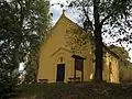 Chapel of the Virgin Mary
References
Wikimedia Commons has media related to Křenice (Klatovy District).
This article is issued from Wikipedia. The text is licensed under Creative Commons - Attribution - Sharealike. Additional terms may apply for the media files.