Běhařov | |
|---|---|
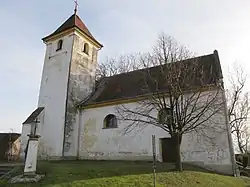 Church of Saint Procopius | |
 Flag  Coat of arms | |
 Běhařov Location in the Czech Republic | |
| Coordinates: 49°20′42″N 13°9′37″E / 49.34500°N 13.16028°E | |
| Country | |
| Region | Plzeň |
| District | Klatovy |
| First mentioned | 1352 |
| Area | |
| • Total | 4.37 km2 (1.69 sq mi) |
| Elevation | 485 m (1,591 ft) |
| Population (2023-01-01)[1] | |
| • Total | 181 |
| • Density | 41/km2 (110/sq mi) |
| Time zone | UTC+1 (CET) |
| • Summer (DST) | UTC+2 (CEST) |
| Postal code | 340 21 |
| Website | www |
Běhařov (German: Wihorschau) is a municipality and village in Klatovy District in the Plzeň Region of the Czech Republic. It has about 200 inhabitants.
Běhařov lies approximately 11 kilometres (7 mi) south-west of Klatovy, 48 km (30 mi) south of Plzeň, and 123 km (76 mi) south-west of Prague.
Administrative parts
The village of Úborsko is an administrative part of Běhařov.
Gallery
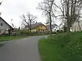 Main street
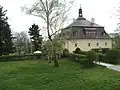 Běhařov Castle
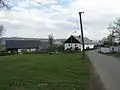 The village of Úborsko
References
Wikimedia Commons has media related to Běhařov.
This article is issued from Wikipedia. The text is licensed under Creative Commons - Attribution - Sharealike. Additional terms may apply for the media files.