Horská Kvilda | |
|---|---|
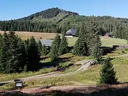 Houses in the village | |
 Flag 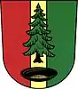 Coat of arms | |
 Horská Kvilda Location in the Czech Republic | |
| Coordinates: 49°3′28″N 13°33′29″E / 49.05778°N 13.55806°E | |
| Country | |
| Region | Plzeň |
| District | Klatovy |
| First mentioned | 1577 |
| Area | |
| • Total | 29.86 km2 (11.53 sq mi) |
| Elevation | 1,070 m (3,510 ft) |
| Population (2023-01-01)[1] | |
| • Total | 70 |
| • Density | 2.3/km2 (6.1/sq mi) |
| Time zone | UTC+1 (CET) |
| • Summer (DST) | UTC+2 (CEST) |
| Postal codes | 341 92, 385 01 |
| Website | www |
Horská Kvilda (German: Innergefild) is a municipality and village in Klatovy District in the Plzeň Region of the Czech Republic. It has about 70 inhabitants.
Horská Kvilda lies approximately 43 kilometres (27 mi) south-east of Klatovy, 78 km (48 mi) south of Plzeň, and 130 km (81 mi) south-west of Prague.
Administrative parts
The hamlet of Korýtko is an administrative part of Horská Kvilda.
References
Wikimedia Commons has media related to Horská Kvilda.
This article is issued from Wikipedia. The text is licensed under Creative Commons - Attribution - Sharealike. Additional terms may apply for the media files.