Châtillon-en-Diois | |
|---|---|
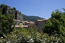 The village of Chatillôn-en-Diois | |
.svg.png.webp) Coat of arms | |
Location of Châtillon-en-Diois | |
 Châtillon-en-Diois  Châtillon-en-Diois | |
| Coordinates: 44°41′44″N 5°29′05″E / 44.6956°N 5.4847°E | |
| Country | France |
| Region | Auvergne-Rhône-Alpes |
| Department | Drôme |
| Arrondissement | Die |
| Canton | Le Diois |
| Intercommunality | Diois |
| Government | |
| • Mayor (2020–2026) | Éric Vanoni[1] |
| Area 1 | 110.06 km2 (42.49 sq mi) |
| Population | 650 |
| • Density | 5.9/km2 (15/sq mi) |
| Time zone | UTC+01:00 (CET) |
| • Summer (DST) | UTC+02:00 (CEST) |
| INSEE/Postal code | 26086 /26410 |
| Elevation | 514–2,038 m (1,686–6,686 ft) |
| 1 French Land Register data, which excludes lakes, ponds, glaciers > 1 km2 (0.386 sq mi or 247 acres) and river estuaries. | |
Châtillon-en-Diois is a commune in the Drôme department in southeastern France. On 1 January 2019, the former commune Treschenu-Creyers was merged into Châtillon-en-Diois.[3]
Population
| Year | Pop. | ±% p.a. |
|---|---|---|
| 1968 | 683 | — |
| 1975 | 623 | −1.30% |
| 1982 | 666 | +0.96% |
| 1990 | 641 | −0.48% |
| 1999 | 631 | −0.17% |
| 2009 | 694 | +0.96% |
| 2014 | 670 | −0.70% |
| 2020 | 658 | −0.30% |
| Source: INSEE[4] | ||
Population data refer to the commune in its geography as of January 2023.
See also
References
- ↑ "Répertoire national des élus: les maires". data.gouv.fr, Plateforme ouverte des données publiques françaises (in French). 2 December 2020.
- ↑ "Populations légales 2021". The National Institute of Statistics and Economic Studies. 28 December 2023.
- ↑ Arrêté préfectoral 21 November 2018 (in French)
- ↑ Population en historique depuis 1968, INSEE
Wikimedia Commons has media related to Châtillon-en-Diois.
This article is issued from Wikipedia. The text is licensed under Creative Commons - Attribution - Sharealike. Additional terms may apply for the media files.