Propiac | |
|---|---|
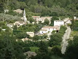 A general view of Propiac | |
Location of Propiac | |
 Propiac  Propiac | |
| Coordinates: 44°16′43″N 5°11′57″E / 44.2786°N 5.1992°E | |
| Country | France |
| Region | Auvergne-Rhône-Alpes |
| Department | Drôme |
| Arrondissement | Nyons |
| Canton | Nyons et Baronnies |
| Government | |
| • Mayor (2021–2026) | Alan Pustoch[1] |
| Area 1 | 11.15 km2 (4.31 sq mi) |
| Population | 134 |
| • Density | 12/km2 (31/sq mi) |
| Time zone | UTC+01:00 (CET) |
| • Summer (DST) | UTC+02:00 (CEST) |
| INSEE/Postal code | 26256 /26170 |
| Elevation | 297–782 m (974–2,566 ft) |
| 1 French Land Register data, which excludes lakes, ponds, glaciers > 1 km2 (0.386 sq mi or 247 acres) and river estuaries. | |
Propiac (French pronunciation: [pʁɔpjak]) is a commune in the Drôme department in southeastern France.
Population
| Year | Pop. | ±% p.a. |
|---|---|---|
| 1968 | 38 | — |
| 1975 | 49 | +3.70% |
| 1982 | 47 | −0.59% |
| 1990 | 60 | +3.10% |
| 1999 | 78 | +2.96% |
| 2009 | 108 | +3.31% |
| 2014 | 110 | +0.37% |
| 2020 | 138 | +3.85% |
| Source: INSEE[3] | ||
See also
References
- ↑ "Répertoire national des élus: les maires". data.gouv.fr, Plateforme ouverte des données publiques françaises (in French). 9 August 2021.
- ↑ "Populations légales 2021". The National Institute of Statistics and Economic Studies. 28 December 2023.
- ↑ Population en historique depuis 1968, INSEE
Wikimedia Commons has media related to Propiac.
This article is issued from Wikipedia. The text is licensed under Creative Commons - Attribution - Sharealike. Additional terms may apply for the media files.