Montaulieu | |
|---|---|
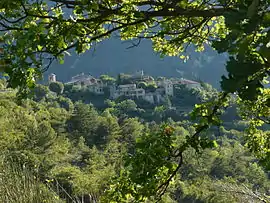 A general view of Montaulieu | |
.svg.png.webp) Coat of arms | |
Location of Montaulieu | |
 Montaulieu  Montaulieu | |
| Coordinates: 44°21′30″N 5°13′29″E / 44.3583°N 5.2247°E | |
| Country | France |
| Region | Auvergne-Rhône-Alpes |
| Department | Drôme |
| Arrondissement | Nyons |
| Canton | Nyons et Baronnies |
| Government | |
| • Mayor (2020–2026) | Stéphane de Coninck[1] |
| Area 1 | 13.05 km2 (5.04 sq mi) |
| Population | 88 |
| • Density | 6.7/km2 (17/sq mi) |
| Time zone | UTC+01:00 (CET) |
| • Summer (DST) | UTC+02:00 (CEST) |
| INSEE/Postal code | 26190 /26110 |
| Elevation | 310–978 m (1,017–3,209 ft) (avg. 500 m or 1,600 ft) |
| 1 French Land Register data, which excludes lakes, ponds, glaciers > 1 km2 (0.386 sq mi or 247 acres) and river estuaries. | |
Montaulieu (French pronunciation: [mɔ̃toljø]; Occitan: Montoliu) is a commune in the Drôme department in southeastern France.
Population
| Year | Pop. | ±% p.a. |
|---|---|---|
| 1968 | 41 | — |
| 1975 | 49 | +2.58% |
| 1982 | 69 | +5.01% |
| 1990 | 51 | −3.71% |
| 1999 | 64 | +2.55% |
| 2009 | 74 | +1.46% |
| 2014 | 81 | +1.82% |
| 2020 | 85 | +0.81% |
| Source: INSEE[3] | ||
See also
References
- ↑ "Répertoire national des élus: les maires". data.gouv.fr, Plateforme ouverte des données publiques françaises (in French). 2 December 2020.
- ↑ "Populations légales 2021". The National Institute of Statistics and Economic Studies. 28 December 2023.
- ↑ Population en historique depuis 1968, INSEE
Wikimedia Commons has media related to Montaulieu.
This article is issued from Wikipedia. The text is licensed under Creative Commons - Attribution - Sharealike. Additional terms may apply for the media files.