La Chapelle-en-Vercors | |
|---|---|
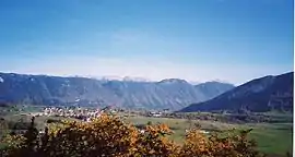 A general view of La Chapelle-en-Vercors | |
_(Dr%C3%B4me).svg.png.webp) Coat of arms | |
Location of La Chapelle-en-Vercors | |
 La Chapelle-en-Vercors  La Chapelle-en-Vercors | |
| Coordinates: 44°58′07″N 5°25′01″E / 44.9686°N 5.4169°E | |
| Country | France |
| Region | Auvergne-Rhône-Alpes |
| Department | Drôme |
| Arrondissement | Die |
| Canton | Vercors-Monts du Matin |
| Government | |
| • Mayor (2020–2026) | Jean-Michel Tarin[1] |
| Area 1 | 45.27 km2 (17.48 sq mi) |
| Population | 748 |
| • Density | 17/km2 (43/sq mi) |
| Time zone | UTC+01:00 (CET) |
| • Summer (DST) | UTC+02:00 (CEST) |
| INSEE/Postal code | 26074 /26420 |
| Elevation | 600–1,524 m (1,969–5,000 ft) |
| 1 French Land Register data, which excludes lakes, ponds, glaciers > 1 km2 (0.386 sq mi or 247 acres) and river estuaries. | |
La Chapelle-en-Vercors (French pronunciation: [la ʃapɛl ɑ̃ vɛʁkɔʁ]; Occitan: Chapèla de Vercòrs) is a commune in the Drôme department in southeastern France.
Population
| Year | Pop. | ±% p.a. |
|---|---|---|
| 1968 | 722 | — |
| 1975 | 675 | −0.96% |
| 1982 | 653 | −0.47% |
| 1990 | 628 | −0.49% |
| 1999 | 662 | +0.59% |
| 2009 | 675 | +0.19% |
| 2014 | 670 | −0.15% |
| 2020 | 724 | +1.30% |
| Source: INSEE[3] | ||
See also
References
- ↑ "Répertoire national des élus: les maires". data.gouv.fr, Plateforme ouverte des données publiques françaises (in French). 9 August 2021.
- ↑ "Populations légales 2021". The National Institute of Statistics and Economic Studies. 28 December 2023.
- ↑ Population en historique depuis 1968, INSEE
Wikimedia Commons has media related to La Chapelle-en-Vercors.
This article is issued from Wikipedia. The text is licensed under Creative Commons - Attribution - Sharealike. Additional terms may apply for the media files.