Proyart | |
|---|---|
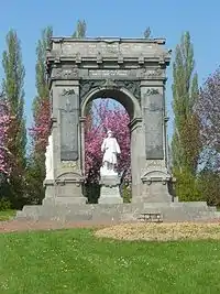 The war memorial in Proyart | |
Location of Proyart | |
 Proyart  Proyart | |
| Coordinates: 49°53′16″N 2°42′29″E / 49.8878°N 2.7081°E | |
| Country | France |
| Region | Hauts-de-France |
| Department | Somme |
| Arrondissement | Péronne |
| Canton | Ham |
| Intercommunality | CC Terre de Picardie |
| Government | |
| • Mayor (2020–2026) | Jean-Claude Louvet[1] |
| Area 1 | 9.86 km2 (3.81 sq mi) |
| Population | 751 |
| • Density | 76/km2 (200/sq mi) |
| Time zone | UTC+01:00 (CET) |
| • Summer (DST) | UTC+02:00 (CEST) |
| INSEE/Postal code | 80644 /80340 |
| Elevation | 32–93 m (105–305 ft) (avg. 85 m or 279 ft) |
| 1 French Land Register data, which excludes lakes, ponds, glaciers > 1 km2 (0.386 sq mi or 247 acres) and river estuaries. | |
Proyart is a commune in the Somme department in Hauts-de-France in northern France.
Geography
Proyart is situated on the D329 road, some 20 miles (32 km) east of Amiens.
Population
| Year | Pop. | ±% p.a. |
|---|---|---|
| 1968 | 527 | — |
| 1975 | 513 | −0.38% |
| 1982 | 509 | −0.11% |
| 1990 | 514 | +0.12% |
| 1999 | 522 | +0.17% |
| 2007 | 607 | +1.90% |
| 2012 | 662 | +1.75% |
| 2017 | 695 | +0.98% |
| Source: INSEE[3] | ||
Places of interest
- War memorial
- The château
See also
References
- ↑ "Répertoire national des élus: les maires". data.gouv.fr, Plateforme ouverte des données publiques françaises (in French). 2 December 2020.
- ↑ "Populations légales 2021". The National Institute of Statistics and Economic Studies. 28 December 2023.
- ↑ Population en historique depuis 1968, INSEE
Wikimedia Commons has media related to Proyart.
This article is issued from Wikipedia. The text is licensed under Creative Commons - Attribution - Sharealike. Additional terms may apply for the media files.