Pouligny-Saint-Pierre | |
|---|---|
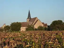 The church of Saint-Pierre, in Pouligny-Saint-Pierre | |
Location of Pouligny-Saint-Pierre | |
 Pouligny-Saint-Pierre  Pouligny-Saint-Pierre | |
| Coordinates: 46°40′54″N 1°02′24″E / 46.6817°N 1.04°E | |
| Country | France |
| Region | Centre-Val de Loire |
| Department | Indre |
| Arrondissement | Le Blanc |
| Canton | Le Blanc |
| Intercommunality | Brenne Val de Creuse |
| Government | |
| • Mayor (2020–2026) | Roland Caillaud[1] |
| Area 1 | 47.45 km2 (18.32 sq mi) |
| Population | 1,022 |
| • Density | 22/km2 (56/sq mi) |
| Time zone | UTC+01:00 (CET) |
| • Summer (DST) | UTC+02:00 (CEST) |
| INSEE/Postal code | 36165 /36300 |
| Elevation | 72–143 m (236–469 ft) (avg. 113 m or 371 ft) |
| 1 French Land Register data, which excludes lakes, ponds, glaciers > 1 km2 (0.386 sq mi or 247 acres) and river estuaries. | |
Pouligny-Saint-Pierre (French pronunciation: [puliɲi sɛ̃ pjɛʁ] ⓘ) is a commune in the Indre department in central France.
The commune is known internationally for its goat's cheese, Pouligny-Saint-Pierre, that was first made in the village in the 19th century.
Geography
The commune is located in the parc naturel régional de la Brenne.
Population
| Year | Pop. | ±% p.a. |
|---|---|---|
| 1968 | 1,018 | — |
| 1975 | 972 | −0.66% |
| 1982 | 982 | +0.15% |
| 1990 | 962 | −0.26% |
| 1999 | 974 | +0.14% |
| 2009 | 1,050 | +0.75% |
| 2014 | 1,095 | +0.84% |
| 2020 | 1,031 | −1.00% |
| Source: INSEE[3] | ||
See also
References
- ↑ "Répertoire national des élus: les maires". data.gouv.fr, Plateforme ouverte des données publiques françaises (in French). 2 December 2020.
- ↑ "Populations légales 2021". The National Institute of Statistics and Economic Studies. 28 December 2023.
- ↑ Population en historique depuis 1968, INSEE
Wikimedia Commons has media related to Pouligny-Saint-Pierre.
This article is issued from Wikipedia. The text is licensed under Creative Commons - Attribution - Sharealike. Additional terms may apply for the media files.