Anstaing | |
|---|---|
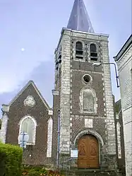 The church in Anstaing | |
 Coat of arms | |
Location of Anstaing | |
 Anstaing  Anstaing | |
| Coordinates: 50°36′21″N 3°11′30″E / 50.6058°N 3.1917°E | |
| Country | France |
| Region | Hauts-de-France |
| Department | Nord |
| Arrondissement | Lille |
| Canton | Templeuve-en-Pévèle |
| Intercommunality | Métropole Européenne de Lille |
| Government | |
| • Mayor (2020–2026) | Étienne Dumoulin[1] |
| Area 1 | 2.3 km2 (0.9 sq mi) |
| Population | 1,601 |
| • Density | 700/km2 (1,800/sq mi) |
| Time zone | UTC+01:00 (CET) |
| • Summer (DST) | UTC+02:00 (CEST) |
| INSEE/Postal code | 59013 /59152 |
| Elevation | 23–40 m (75–131 ft) (avg. 27 m or 89 ft) |
| 1 French Land Register data, which excludes lakes, ponds, glaciers > 1 km2 (0.386 sq mi or 247 acres) and river estuaries. | |
Anstaing (French pronunciation: [ɑ̃stɛ̃]) is a commune in the Nord department in northern France.[3]
The name is probably of Germanic origin, meaning "village of Anst".[4]
Population
| Year | Pop. | ±% p.a. |
|---|---|---|
| 1968 | 1,007 | — |
| 1975 | 972 | −0.50% |
| 1982 | 1,058 | +1.22% |
| 1990 | 1,115 | +0.66% |
| 1999 | 1,183 | +0.66% |
| 2009 | 1,220 | +0.31% |
| 2014 | 1,375 | +2.42% |
| 2020 | 1,559 | +2.12% |
| Source: INSEE[5] | ||
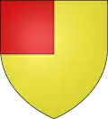
Heraldry
Arms of Anstaing |
The arms of Anstaing are blazoned : Or, a canton gules. (Anstaing and Sainghin-en-Mélantois use the same arms.)
|
See also
References
- ↑ "Répertoire national des élus: les maires". data.gouv.fr, Plateforme ouverte des données publiques françaises (in French). 2 December 2020.
- ↑ "Populations légales 2021". The National Institute of Statistics and Economic Studies. 28 December 2023.
- ↑ INSEE commune file
- ↑ Anstaing official Web site Archived November 30, 2008, at the Wayback Machine
- ↑ Population en historique depuis 1968, INSEE
Wikimedia Commons has media related to Anstaing.
This article is issued from Wikipedia. The text is licensed under Creative Commons - Attribution - Sharealike. Additional terms may apply for the media files.