Cartignies | |
|---|---|
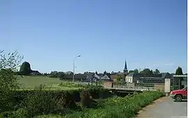 A general view of Cartignies | |
 Coat of arms | |
Location of Cartignies | |
 Cartignies  Cartignies | |
| Coordinates: 50°05′36″N 3°50′48″E / 50.0933°N 3.8467°E | |
| Country | France |
| Region | Hauts-de-France |
| Department | Nord |
| Arrondissement | Avesnes-sur-Helpe |
| Canton | Avesnes-sur-Helpe |
| Intercommunality | CC Cœur de l'Avesnois |
| Government | |
| • Mayor (2020–2026) | Sabine Caufapé-Soumier[1] |
| Area 1 | 26.41 km2 (10.20 sq mi) |
| Population | 1,260 |
| • Density | 48/km2 (120/sq mi) |
| Time zone | UTC+01:00 (CET) |
| • Summer (DST) | UTC+02:00 (CEST) |
| INSEE/Postal code | 59134 /59244 |
| Elevation | 140–213 m (459–699 ft) (avg. 150 m or 490 ft) |
| 1 French Land Register data, which excludes lakes, ponds, glaciers > 1 km2 (0.386 sq mi or 247 acres) and river estuaries. | |
Cartignies (French pronunciation: [kaʁtiɲi]) is a commune in the Nord department in northern France.[3]
Heraldry
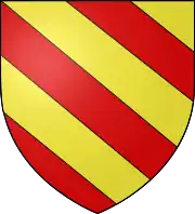
Arms of Cartignies |
The arms of Cartignies are blazoned : Bendy Or and gules. (Avesnes-sur-Helpe, Cartignies, Damousies, Dimechaux, Dimont, Felleries, Larouillies, Lomme, and Ramousies use the same arms.)
|
See also
References
- ↑ "Répertoire national des élus: les maires" (in French). data.gouv.fr, Plateforme ouverte des données publiques françaises. 13 September 2022.
- ↑ "Populations légales 2021". The National Institute of Statistics and Economic Studies. 28 December 2023.
- ↑ INSEE commune file
Wikimedia Commons has media related to Cartignies.
This article is issued from Wikipedia. The text is licensed under Creative Commons - Attribution - Sharealike. Additional terms may apply for the media files.