Emmerin | |
|---|---|
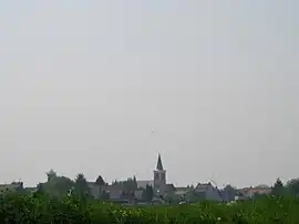 A general view of Emmerin | |
 Coat of arms | |
Location of Emmerin | |
 Emmerin  Emmerin | |
| Coordinates: 50°35′39″N 3°00′09″E / 50.5942°N 3.0025°E | |
| Country | France |
| Region | Hauts-de-France |
| Department | Nord |
| Arrondissement | Lille |
| Canton | Faches-Thumesnil |
| Intercommunality | Métropole Européenne de Lille |
| Government | |
| • Mayor (2020–2026) | Danièle Ponchaux[1] |
| Area 1 | 4.91 km2 (1.90 sq mi) |
| Population | 3,053 |
| • Density | 620/km2 (1,600/sq mi) |
| Time zone | UTC+01:00 (CET) |
| • Summer (DST) | UTC+02:00 (CEST) |
| INSEE/Postal code | 59193 /59320 |
| Elevation | 17–41 m (56–135 ft) (avg. 22 m or 72 ft) |
| 1 French Land Register data, which excludes lakes, ponds, glaciers > 1 km2 (0.386 sq mi or 247 acres) and river estuaries. | |
Emmerin (French pronunciation: [ɛmʁɛ̃]) is a commune in the Nord department in northern France. It is part of the Métropole Européenne de Lille.[3]
Population
| Year | Pop. | ±% p.a. |
|---|---|---|
| 1968 | 2,109 | — |
| 1975 | 2,313 | +1.33% |
| 1982 | 2,411 | +0.59% |
| 1990 | 2,997 | +2.76% |
| 1999 | 3,029 | +0.12% |
| 2007 | 3,030 | +0.00% |
| 2012 | 3,210 | +1.16% |
| 2017 | 3,172 | −0.24% |
| Source: INSEE[4] | ||
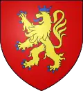
Heraldry
Arms of Emmerin |
The arms of Emmerin are blazoned : Gules, a lion Or, armed, langued and crowned azure. (Aix-en-Pévèle, Emmerin, and Haubourdin use the same arms.)
|
See also
References
- ↑ "Répertoire national des élus: les maires". data.gouv.fr, Plateforme ouverte des données publiques françaises (in French). 2 December 2020.
- ↑ "Populations légales 2021". The National Institute of Statistics and Economic Studies. 28 December 2023.
- ↑ INSEE commune file
- ↑ Population en historique depuis 1968, INSEE
Wikimedia Commons has media related to Emmerin.
This article is issued from Wikipedia. The text is licensed under Creative Commons - Attribution - Sharealike. Additional terms may apply for the media files.