Solutré-Pouilly | |
|---|---|
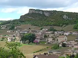 A general view of Solutré-Pouilly | |
Location of Solutré-Pouilly | |
 Solutré-Pouilly  Solutré-Pouilly | |
| Coordinates: 46°17′47″N 4°43′29″E / 46.2965°N 4.72470°E | |
| Country | France |
| Region | Bourgogne-Franche-Comté |
| Department | Saône-et-Loire |
| Arrondissement | Mâcon |
| Canton | La Chapelle-de-Guinchay |
| Intercommunality | Mâconnais Beaujolais Agglomération |
| Area 1 | 6.16 km2 (2.38 sq mi) |
| Population | 353 |
| • Density | 57/km2 (150/sq mi) |
| Time zone | UTC+01:00 (CET) |
| • Summer (DST) | UTC+02:00 (CEST) |
| INSEE/Postal code | 71526 /71960 |
| Elevation | 208–530 m (682–1,739 ft) (avg. 400 m or 1,300 ft) |
| 1 French Land Register data, which excludes lakes, ponds, glaciers > 1 km2 (0.386 sq mi or 247 acres) and river estuaries. | |
Solutré-Pouilly (French pronunciation: [sɔlytʁe puji]; Arpitan: Selutrié-Polyié) is a commune in the Saône-et-Loire department in the region of Bourgogne-Franche-Comté in eastern France. It is known for a local geological feature, the Rock of Solutré.
Wine
The vineyards of Solutré-Pouilly are part of the appellation d'origine contrôlée Pouilly-Fuissé. Local wineries include the Domaine du Chalet Pouilly.
Points of interest
See also
- Solutrean, the Paleolithic style named after a site near the village.
- Communes of the Saône-et-Loire department
- Rock of Solutré
References
- ↑ "Populations légales 2021". The National Institute of Statistics and Economic Studies. 28 December 2023.
Wikimedia Commons has media related to Solutré-Pouilly.
This article is issued from Wikipedia. The text is licensed under Creative Commons - Attribution - Sharealike. Additional terms may apply for the media files.