Vergisson | |
|---|---|
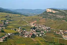 A general view of Vergisson | |
.svg.png.webp) Coat of arms | |
Location of Vergisson | |
 Vergisson  Vergisson | |
| Coordinates: 46°18′32″N 4°42′55″E / 46.3088°N 4.71520°E | |
| Country | France |
| Region | Bourgogne-Franche-Comté |
| Department | Saône-et-Loire |
| Arrondissement | Mâcon |
| Canton | La Chapelle-de-Guinchay |
| Intercommunality | Mâconnais Beaujolais Agglomération |
| Area 1 | 5.77 km2 (2.23 sq mi) |
| Population | 244 |
| • Density | 42/km2 (110/sq mi) |
| Time zone | UTC+01:00 (CET) |
| • Summer (DST) | UTC+02:00 (CEST) |
| INSEE/Postal code | 71567 /71960 |
| Elevation | 255–575 m (837–1,886 ft) (avg. 320 m or 1,050 ft) |
| 1 French Land Register data, which excludes lakes, ponds, glaciers > 1 km2 (0.386 sq mi or 247 acres) and river estuaries. | |
Vergisson (French pronunciation: [vɛʁʒisɔ̃]) is a commune in the Saône-et-Loire department in the region of Bourgogne-Franche-Comté in eastern France.
Wine
The vineyards of Vergisson form part of the appellation d'origine contrôlée Pouilly-Fuissé.
Gallery
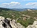 View from Rock of Solutré.
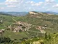 View from Rock of Vergisson.
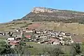 View from Menhir de Chancerons.
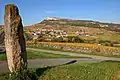 Menhir de Chancerons.
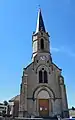 Église Saint-Martin.
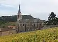 Église Saint-Martin (view N).
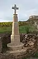 Wayside cross (1855).
See also
References
- ↑ "Populations légales 2021". The National Institute of Statistics and Economic Studies. 28 December 2023.
Wikimedia Commons has media related to Vergisson.
This article is issued from Wikipedia. The text is licensed under Creative Commons - Attribution - Sharealike. Additional terms may apply for the media files.