Averdoingt | |
|---|---|
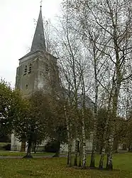 The church of Averdoingt | |
 Coat of arms | |
Location of Averdoingt | |
 Averdoingt  Averdoingt | |
| Coordinates: 50°20′43″N 2°26′34″E / 50.3453°N 2.4428°E | |
| Country | France |
| Region | Hauts-de-France |
| Department | Pas-de-Calais |
| Arrondissement | Arras |
| Canton | Saint-Pol-sur-Ternoise |
| Intercommunality | CC du Ternois |
| Government | |
| • Mayor (2020–2026) | Damien Montel[1] |
| Area 1 | 8.33 km2 (3.22 sq mi) |
| Population | 291 |
| • Density | 35/km2 (90/sq mi) |
| Time zone | UTC+01:00 (CET) |
| • Summer (DST) | UTC+02:00 (CEST) |
| INSEE/Postal code | 62061 /62127 |
| Elevation | 123–156 m (404–512 ft) (avg. 148 m or 486 ft) |
| 1 French Land Register data, which excludes lakes, ponds, glaciers > 1 km2 (0.386 sq mi or 247 acres) and river estuaries. | |
Averdoingt (French pronunciation: [avɛʁdwɛ̃]) is a commune in the Pas-de-Calais department in northern France.[3]
Geography
A small farming village located 19 miles (30 km) west of Arras at the junction of the D81 and D81E roads.
Population
| Year | Pop. | ±% |
|---|---|---|
| 1962 | 220 | — |
| 1968 | 221 | +0.5% |
| 1975 | 208 | −5.9% |
| 1982 | 207 | −0.5% |
| 1990 | 244 | +17.9% |
| 1999 | 251 | +2.9% |
| 2006 | 263 | +4.8% |
| 2007 | 265 | +0.8% |
| 2008 | 266 | +0.4% |
| 2009 | 263 | −1.1% |
| 2013 | 285 | +8.4% |
| 2014 | 290 | +1.8% |
| 2015 | 290 | +0.0% |
Sights
- The ruins of a 12th-century castle.
- The church of St. Leger, dating from the thirteenth century.
See also
References
- ↑ "Répertoire national des élus: les maires". data.gouv.fr, Plateforme ouverte des données publiques françaises (in French). 2 December 2020.
- ↑ "Populations légales 2021". The National Institute of Statistics and Economic Studies. 28 December 2023.
- ↑ INSEE commune file
Wikimedia Commons has media related to Averdoingt.
This article is issued from Wikipedia. The text is licensed under Creative Commons - Attribution - Sharealike. Additional terms may apply for the media files.