Maizières | |
|---|---|
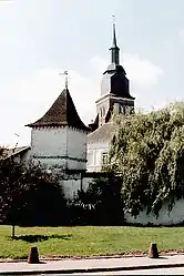 Dovecote and the church | |
 Coat of arms | |
Location of Maizières | |
 Maizières  Maizières | |
| Coordinates: 50°19′28″N 2°26′55″E / 50.3244°N 2.4486°E | |
| Country | France |
| Region | Hauts-de-France |
| Department | Pas-de-Calais |
| Arrondissement | Arras |
| Canton | Avesnes-le-Comte |
| Intercommunality | CC Campagnes de l'Artois |
| Government | |
| • Mayor (2020–2026) | Raymond Lavigne[1] |
| Area 1 | 6.86 km2 (2.65 sq mi) |
| Population | 203 |
| • Density | 30/km2 (77/sq mi) |
| Time zone | UTC+01:00 (CET) |
| • Summer (DST) | UTC+02:00 (CEST) |
| INSEE/Postal code | 62542 /62127 |
| Elevation | 123–153 m (404–502 ft) (avg. 145 m or 476 ft) |
| 1 French Land Register data, which excludes lakes, ponds, glaciers > 1 km2 (0.386 sq mi or 247 acres) and river estuaries. | |
Maizières (French pronunciation: [mɛzjɛʁ] ⓘ) is a commune in the Pas-de-Calais department in the Hauts-de-France region of France.[3]
Geography
Maizières is situated 16 miles (26 km) west of Arras, at the junction of the D8, D81 and the D82 roads.
Population
| Year | Pop. | ±% p.a. |
|---|---|---|
| 1968 | 223 | — |
| 1975 | 175 | −3.40% |
| 1982 | 173 | −0.16% |
| 1990 | 177 | +0.29% |
| 1999 | 177 | +0.00% |
| 2007 | 162 | −1.10% |
| 2012 | 174 | +1.44% |
| 2017 | 193 | +2.09% |
| Source: INSEE[4] | ||
Places of interest
- The church of St.Leger, dating from the seventeenth century.
- An old dovecote.
See also
References
- ↑ "Répertoire national des élus: les maires" (in French). data.gouv.fr, Plateforme ouverte des données publiques françaises. 13 September 2022.
- ↑ "Populations légales 2021". The National Institute of Statistics and Economic Studies. 28 December 2023.
- ↑ INSEE commune file
- ↑ Population en historique depuis 1968, INSEE
Wikimedia Commons has media related to Maizières (Pas-de-Calais).
This article is issued from Wikipedia. The text is licensed under Creative Commons - Attribution - Sharealike. Additional terms may apply for the media files.