Hestrus | |
|---|---|
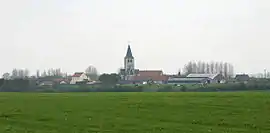 A general view of Hestrus | |
 Coat of arms | |
Location of Hestrus | |
 Hestrus  Hestrus | |
| Coordinates: 50°26′55″N 2°19′52″E / 50.4486°N 2.3311°E / 50.4486; 2.3311 | |
| Country | France |
| Region | Hauts-de-France |
| Department | Pas-de-Calais |
| Arrondissement | Arras |
| Canton | Saint-Pol-sur-Ternoise |
| Intercommunality | CC Ternois |
| Government | |
| • Mayor (2020–2026) | Philippe Ducatel[1] |
| Area 1 | 7.8 km2 (3.0 sq mi) |
| Population | 222 |
| • Density | 28/km2 (74/sq mi) |
| Time zone | UTC+01:00 (CET) |
| • Summer (DST) | UTC+02:00 (CEST) |
| INSEE/Postal code | 62450 /62550 |
| Elevation | 85–167 m (279–548 ft) (avg. 151 m or 495 ft) |
| 1 French Land Register data, which excludes lakes, ponds, glaciers > 1 km2 (0.386 sq mi or 247 acres) and river estuaries. | |
Hestrus is a commune in the Pas-de-Calais department in the Hauts-de-France region of France.[3]
Geography
A farming village situated 25 miles (40 km) northwest of Arras, at the junction of the D99 and the D70E4 roads.
Population
| Year | Pop. | ±% p.a. |
|---|---|---|
| 1968 | 323 | — |
| 1975 | 292 | −1.43% |
| 1982 | 276 | −0.80% |
| 1990 | 272 | −0.18% |
| 1999 | 239 | −1.43% |
| 2007 | 227 | −0.64% |
| 2012 | 251 | +2.03% |
| 2017 | 243 | −0.65% |
| Source: INSEE[4] | ||
Places of interest
- The church of Notre-Dame, dating from the seventeenth century.
See also
References
- ↑ "Répertoire national des élus: les maires". data.gouv.fr, Plateforme ouverte des données publiques françaises (in French). 9 August 2021.
- ↑ "Populations légales 2021". The National Institute of Statistics and Economic Studies. 28 December 2023.
- ↑ INSEE commune file
- ↑ Population en historique depuis 1968, INSEE
Wikimedia Commons has media related to Hestrus.
This article is issued from Wikipedia. The text is licensed under Creative Commons - Attribution - Sharealike. Additional terms may apply for the media files.