Marles-sur-Canche | |
|---|---|
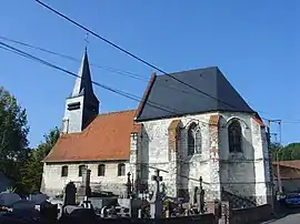 The church of Marles-sur-Canche | |
 Coat of arms | |
Location of Marles-sur-Canche | |
 Marles-sur-Canche  Marles-sur-Canche | |
| Coordinates: 50°27′31″N 1°49′41″E / 50.4586°N 1.8281°E | |
| Country | France |
| Region | Hauts-de-France |
| Department | Pas-de-Calais |
| Arrondissement | Montreuil |
| Canton | Auxi-le-Château |
| Intercommunality | CC des 7 Vallées |
| Government | |
| • Mayor (2020–2026) | Joël Davesne[1] |
| Area 1 | 5.1 km2 (2.0 sq mi) |
| Population | 314 |
| • Density | 62/km2 (160/sq mi) |
| Time zone | UTC+01:00 (CET) |
| • Summer (DST) | UTC+02:00 (CEST) |
| INSEE/Postal code | 62556 /62170 |
| Elevation | 5–79 m (16–259 ft) (avg. 46 m or 151 ft) |
| 1 French Land Register data, which excludes lakes, ponds, glaciers > 1 km2 (0.386 sq mi or 247 acres) and river estuaries. | |
Marles-sur-Canche (French pronunciation: [maʁl syʁ kɑ̃ʃ], literally Marles on Canche) is a commune in the Pas-de-Calais department in the Hauts-de-France region of France.[3]
Geography
Marles-sur-Canche is situated in the valley of the Canche river, 2.3 miles (4 km) southeast of Montreuil-sur-Mer, on the D113 road.
Population
| Year | Pop. | ±% p.a. |
|---|---|---|
| 1968 | 268 | — |
| 1975 | 259 | −0.49% |
| 1982 | 274 | +0.81% |
| 1990 | 293 | +0.84% |
| 1999 | 294 | +0.04% |
| 2007 | 296 | +0.08% |
| 2012 | 284 | −0.82% |
| 2017 | 299 | +1.03% |
| Source: INSEE[4] | ||
Places of interest
- The seventeenth century church of St. Firmin.
See also
References
- ↑ "Répertoire national des élus: les maires" (in French). data.gouv.fr, Plateforme ouverte des données publiques françaises. 13 September 2022.
- ↑ "Populations légales 2021". The National Institute of Statistics and Economic Studies. 28 December 2023.
- ↑ INSEE commune file
- ↑ Population en historique depuis 1968, INSEE
Wikimedia Commons has media related to Marles-sur-Canche.
This article is issued from Wikipedia. The text is licensed under Creative Commons - Attribution - Sharealike. Additional terms may apply for the media files.