Bus | |
|---|---|
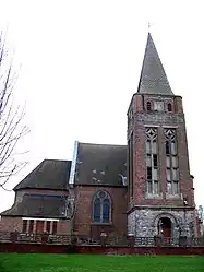 The church of Bus | |
.svg.png.webp) Coat of arms | |
Location of Bus | |
 Bus  Bus | |
| Coordinates: 50°03′58″N 2°57′56″E / 50.0661°N 2.9656°E | |
| Country | France |
| Region | Hauts-de-France |
| Department | Pas-de-Calais |
| Arrondissement | Arras |
| Canton | Bapaume |
| Intercommunality | CC Sud-Artois |
| Government | |
| • Mayor (2020–2026) | Guy Alexandre[1] |
| Area 1 | 3.24 km2 (1.25 sq mi) |
| Population | 133 |
| • Density | 41/km2 (110/sq mi) |
| Time zone | UTC+01:00 (CET) |
| • Summer (DST) | UTC+02:00 (CEST) |
| INSEE/Postal code | 62189 /62124 |
| Elevation | 113–132 m (371–433 ft) (avg. 134 m or 440 ft) |
| 1 French Land Register data, which excludes lakes, ponds, glaciers > 1 km2 (0.386 sq mi or 247 acres) and river estuaries. | |
Bus (/by/[3]) is a commune in the Pas-de-Calais department in the Hauts-de-France region in northern France.[4]
Geography
A small farming village located 22 miles (35 km) southeast of Arras on the D19 road, at the junction with the D7E. The A2 autoroute passes by just yards from the commune.
Demographics
| Year | Pop. | ±% |
|---|---|---|
| 1962 | 98 | — |
| 1968 | 118 | +20.4% |
| 1975 | 103 | −12.7% |
| 1982 | 96 | −6.8% |
| 1990 | 90 | −6.2% |
| 1999 | 105 | +16.7% |
| 2009 | 116 | +10.5% |
Sights
- The church of Notre-Dame, dating from the twentieth century.
See also
References
- ↑ "Répertoire national des élus: les maires". data.gouv.fr, Plateforme ouverte des données publiques françaises (in French). 9 August 2021.
- ↑ "Populations légales 2021". The National Institute of Statistics and Economic Studies. 28 December 2023.
- ↑ https://www.youtube.com/watch?v=XPB1vTY3kyM
- ↑ INSEE commune file
External links
Wikimedia Commons has media related to Bus (Pas-de-Calais).
- Bus on the Quid website (in French)
This article is issued from Wikipedia. The text is licensed under Creative Commons - Attribution - Sharealike. Additional terms may apply for the media files.