Bours | |
|---|---|
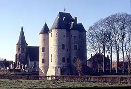 The château of Bours | |
Location of Bours | |
 Bours  Bours | |
| Coordinates: 50°27′19″N 2°24′21″E / 50.4553°N 2.4058°E | |
| Country | France |
| Region | Hauts-de-France |
| Department | Pas-de-Calais |
| Arrondissement | Arras |
| Canton | Saint-Pol-sur-Ternoise |
| Intercommunality | CC Ternois |
| Government | |
| • Mayor (2020–2026) | Bertrand Beaucamp[1] |
| Area 1 | 11.84 km2 (4.57 sq mi) |
| Population | 600 |
| • Density | 51/km2 (130/sq mi) |
| Time zone | UTC+01:00 (CET) |
| • Summer (DST) | UTC+02:00 (CEST) |
| INSEE/Postal code | 62166 /62550 |
| Elevation | 83–184 m (272–604 ft) (avg. 171 m or 561 ft) |
| 1 French Land Register data, which excludes lakes, ponds, glaciers > 1 km2 (0.386 sq mi or 247 acres) and river estuaries. | |
Bours (French pronunciation: [buʁ]) is a commune in the Pas-de-Calais department in the Hauts-de-France region in northern France.[3]
Geography
A farming village located 20 miles (32 km) northwest of Arras on the D89 road, in the valley of the river Clarence.
Population
| Year | Pop. | ±% |
|---|---|---|
| 1962 | 493 | — |
| 1968 | 545 | +10.5% |
| 1975 | 510 | −6.4% |
| 1982 | 505 | −1.0% |
| 1990 | 524 | +3.8% |
| 1999 | 509 | −2.9% |
| 2009 | 571 | +12.2% |
Sights
- The church of Sainte-Austreberthe, dating from the eleventh century.
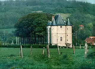
- The (restored) castle donjon, also from the eleventh century. Built of sandstone by Hugues de Bours.
See also
References
- ↑ "Répertoire national des élus: les maires". data.gouv.fr, Plateforme ouverte des données publiques françaises (in French). 9 August 2021.
- ↑ "Populations légales 2021". The National Institute of Statistics and Economic Studies. 28 December 2023.
- ↑ INSEE commune file
Wikimedia Commons has media related to Bours, Pas-de-Calais.
This article is issued from Wikipedia. The text is licensed under Creative Commons - Attribution - Sharealike. Additional terms may apply for the media files.