Ambérieux-en-Dombes | |
|---|---|
Commune | |
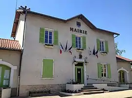 Town hall | |
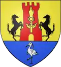 Coat of arms | |
Location of Ambérieux-en-Dombes | |
 Ambérieux-en-Dombes  Ambérieux-en-Dombes | |
| Coordinates: 45°59′57″N 4°54′12″E / 45.9992°N 4.9033°E | |
| Country | France |
| Region | Auvergne-Rhône-Alpes |
| Department | Ain |
| Arrondissement | Bourg-en-Bresse |
| Canton | Villars-les-Dombes |
| Intercommunality | Dombes Saône Vallée |
| Government | |
| • Mayor (2021–2026) | Christine Fornes[1] |
| Area 1 | 15.92 km2 (6.15 sq mi) |
| Population | 1,897 |
| • Density | 120/km2 (310/sq mi) |
| Time zone | UTC+01:00 (CET) |
| • Summer (DST) | UTC+02:00 (CEST) |
| INSEE/Postal code | 01005 /01330 |
| Elevation | 265–302 m (869–991 ft) (avg. 300 m or 980 ft) |
| 1 French Land Register data, which excludes lakes, ponds, glaciers > 1 km2 (0.386 sq mi or 247 acres) and river estuaries. | |
Ambérieux-en-Dombes (French pronunciation: [ɑ̃beʁjø ɑ̃ dɔ̃b] ⓘ, literally Ambérieux in Dombes) is a commune in the department of Ain in the Auvergne-Rhône-Alpes region of eastern France.
The inhabitants of the commune are known as Ambarrois or Ambarroises[3]
Geography
As its name suggests, Ambérieux-en-Dombes is a part of the Dombes country in Ain. It is located some 10 km east of Villefranche-sur-Saone and 35 km north of Lyon. There are several access roads to the commune: the D904 comes from Savigneux in the west through the heart of the commune and the town and continues east to Lapeyrouse; the D66 road from Saint-Trivier-sur-Moignans in the north passes through the town and continues south to Saint-Jean-de-Thurigneux; the D660 comes from Rancé in the south-west to the town; and the D82 comes from Monthieux in the south-east and continues to Chatillon-sur-Chalaronne in the north-east. All of these roads intersect in or very near the town.[4]
There is a network of country roads covering the commune which is entirely farmland outside the built-up areas. Apart from the town there is the hamlet of La Jonchay to the north-east of the town.
There are many étangs or ponds in the commune, particularly in the east but almost no waterways.[4]
Neighbouring communes and villages[4] | ||||||||||||||||
|---|---|---|---|---|---|---|---|---|---|---|---|---|---|---|---|---|
| ||||||||||||||||
History
The village was known as Ambariacum in the 6th century and the land belonged to the castles of the first Burgundian kings.
On 13 July 1922 a train of the Compagnie des Tramways de l'Ain returning pilgrims from Ars-sur-Formans derailed between Ambérieux-en-Dombes and Lapeyrouse leaving one dead and several injured.[5]
Heraldry
Arms of Ambérieux-en-Dombes |
The official emblem is still to be determined.
Blazon:
|
Administration
List of Successive Mayors of Ambérieux-en-Dombes [7]
| From | To | Name |
|---|---|---|
| 1995 | 2001 | Jean Giroux |
| 2001 | 2014 | Bernard Ravoire |
| 2014 | Present | Pierre Pernet |
Population
|
| ||||||||||||||||||||||||||||||||||||||||||||||||||||||||||||||||||||||||||||||||||||||||||||||||||||||||||||||||||
| Source: EHESS (1793-1999)[8] and INSEE[9] | |||||||||||||||||||||||||||||||||||||||||||||||||||||||||||||||||||||||||||||||||||||||||||||||||||||||||||||||||||
Culture and heritage
Sites and monuments
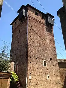
- The Chateau of Ambérieux-en-Dombes (15th century)
 is registered as an historical monument.[10] It was built between 1370 and 1376 (dendrochronological study) during the reign of Humbert V of Thoire and Villars. It is located in the centre of the village today and still has four towers - three square towers 19 metres tall and a round tower of small diameter which served as a prison. The dungeon has been completely restored with the installation of a new roof in 2010.[11]
 - The War Memorial has the feature of being topped by a rooster.
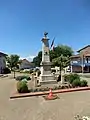 The War Memorial.
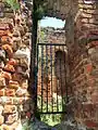 Door to the Castle.
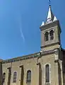 View of the Village Church.
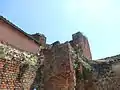 Ruins of the Castle
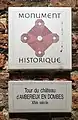 Historical monument plaque on the Chateau
Notable people linked to the commune
- Laurent Capponi (1512-1573), Lord of Ambérieux-en-Dombes
- Jean Saint-Cyr (1899-1990), French politician, born in Ambérieux-en-Dombes
- Gundobad, the 6th-century king of the Burgundians, born in the commune
See also
References
- ↑ "Répertoire national des élus: les maires". data.gouv.fr, Plateforme ouverte des données publiques françaises (in French). 9 August 2021.
- ↑ "Populations légales 2021". The National Institute of Statistics and Economic Studies. 28 December 2023.
- ↑ Inhabitants of Ain (in French)
- 1 2 3 Google Maps
- ↑ La Presse of 15 July 1922, p. 1.
- ↑ Article Ambérieux-en-Dombes on the Blazon Bank
- ↑ The Mayors of Ambérieux-en-Dombes, consulted on 23 June 2010. (in French)
- ↑ Des villages de Cassini aux communes d'aujourd'hui: Commune data sheet Ambérieux-en-Dombes, EHESS (in French).
- ↑ Population en historique depuis 1968, INSEE
- ↑ Ministry of Culture, Mérimée PA00116290 Chateau of Ambérieux-en-Dombes (in French)

- ↑ The Castle on the Town Hall website of Ambérieux
External links
- Ambérieux-en-Dombes on the La Dombes website (in French)
- Ambérieux-en-Dombes official website (in French)
- Ambérieux-en-Dombes on Géoportail, National Geographic Institute (IGN) website (in French)
- Amberieux en Dombe on the 1750 Cassini Map