Jasseron | |
|---|---|
Commune | |
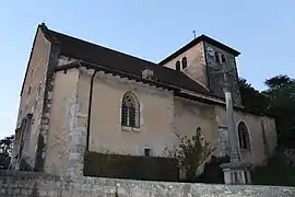 Church of St. John the Baptist | |
.svg.png.webp) Coat of arms | |
Location of Jasseron | |
 Jasseron  Jasseron | |
| Coordinates: 46°13′00″N 5°20′00″E / 46.2167°N 5.3333°E | |
| Country | France |
| Region | Auvergne-Rhône-Alpes |
| Department | Ain |
| Arrondissement | Bourg-en-Bresse |
| Canton | Saint-Étienne-du-Bois |
| Intercommunality | CA Bassin de Bourg-en-Bresse |
| Government | |
| • Mayor (2020–2026) | Sébastien Gobert[1] |
| Area 1 | 18.93 km2 (7.31 sq mi) |
| Population | 1,861 |
| • Density | 98/km2 (250/sq mi) |
| Time zone | UTC+01:00 (CET) |
| • Summer (DST) | UTC+02:00 (CEST) |
| INSEE/Postal code | 01195 /01250 |
| Elevation | 246–590 m (807–1,936 ft) (avg. 320 m or 1,050 ft) |
| 1 French Land Register data, which excludes lakes, ponds, glaciers > 1 km2 (0.386 sq mi or 247 acres) and river estuaries. | |
Jasseron (French pronunciation: [ʒasʁɔ̃]; Occitan: Jâsseron) is a commune in the Ain department in eastern France.
It is located 7 km (4.3 mi) east of Bourg-en-Bresse.
Population
| Year | Pop. | ±% p.a. |
|---|---|---|
| 1968 | 654 | — |
| 1975 | 716 | +1.30% |
| 1982 | 954 | +4.18% |
| 1990 | 1,079 | +1.55% |
| 1999 | 1,256 | +1.70% |
| 2009 | 1,482 | +1.67% |
| 2014 | 1,709 | +2.89% |
| 2020 | 1,822 | +1.07% |
| Source: INSEE[3] | ||
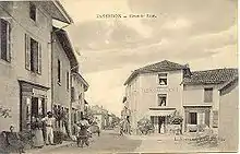
Jasseron c.1900
See also
References
- ↑ "Répertoire national des élus: les maires". data.gouv.fr, Plateforme ouverte des données publiques françaises (in French). 2 December 2020.
- ↑ "Populations légales 2021". The National Institute of Statistics and Economic Studies. 28 December 2023.
- ↑ Population en historique depuis 1968, INSEE
External links
Wikimedia Commons has media related to Jasseron.
This article is issued from Wikipedia. The text is licensed under Creative Commons - Attribution - Sharealike. Additional terms may apply for the media files.