Bellignat | |
|---|---|
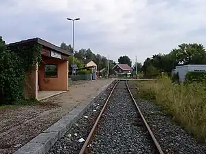 Train station | |
.svg.png.webp) Coat of arms | |
Location of Bellignat | |
 Bellignat  Bellignat | |
| Coordinates: 46°14′41″N 5°37′58″E / 46.2447°N 5.6328°E | |
| Country | France |
| Region | Auvergne-Rhône-Alpes |
| Department | Ain |
| Arrondissement | Nantua |
| Canton | Nantua |
| Intercommunality | Haut-Bugey Agglomération |
| Government | |
| • Mayor (2020–2026) | Véronique Ravet[1] |
| Area 1 | 7.84 km2 (3.03 sq mi) |
| Population | 3,636 |
| • Density | 460/km2 (1,200/sq mi) |
| Time zone | UTC+01:00 (CET) |
| • Summer (DST) | UTC+02:00 (CEST) |
| INSEE/Postal code | 01031 /01810 |
| Elevation | 516–913 m (1,693–2,995 ft) (avg. 521 m or 1,709 ft) |
| 1 French Land Register data, which excludes lakes, ponds, glaciers > 1 km2 (0.386 sq mi or 247 acres) and river estuaries. | |
Bellignat (French pronunciation: [bɛliɲa]) is a commune in the Ain department in eastern France. Bellignat station has rail connections to Bourg-en-Bresse and Oyonnax.
Population
| Year | Pop. | ±% p.a. |
|---|---|---|
| 1968 | 832 | — |
| 1975 | 1,077 | +3.76% |
| 1982 | 2,602 | +13.43% |
| 1990 | 3,233 | +2.75% |
| 1999 | 3,488 | +0.85% |
| 2007 | 3,472 | −0.06% |
| 2012 | 3,642 | +0.96% |
| 2017 | 3,624 | −0.10% |
| Source: INSEE[3] | ||
See also
References
- ↑ "Répertoire national des élus: les maires" (in French). data.gouv.fr, Plateforme ouverte des données publiques françaises. 13 September 2022.
- ↑ "Populations légales 2021". The National Institute of Statistics and Economic Studies. 28 December 2023.
- ↑ Population en historique depuis 1968, INSEE
External links
Wikimedia Commons has media related to Bellignat.
This article is issued from Wikipedia. The text is licensed under Creative Commons - Attribution - Sharealike. Additional terms may apply for the media files.